You are here: Home > Network List > C1 - Red Sismologica Nacional Stations List
> Station MT09 Talagante > Earthquake Result Viewer
MT09 Talagante - Earthquake Result Viewer
| Earthquake location: |
South Sandwich Islands Region |
| Earthquake latitude/longitude: |
-56.2/-26.9 |
| Earthquake time(UTC): |
2016/05/28 (149) 09:46:59 GMT |
| Earthquake Depth: |
73 km |
| Earthquake Magnitude: |
7.2 MWW, 7.3 MI |
| Earthquake Catalog/Contributor: |
NEIC PDE/NEIC COMCAT |
|
| Network: |
C1 Red Sismologica Nacional |
| Station: |
MT09 Talagante |
| Lat/Lon: |
33.78 S/70.99 W |
| Elevation: |
1371 m |
|
| Distance: |
37.5 deg |
| Az: |
287.866 deg |
| Baz: |
140.315 deg |
| Ray Param: |
0.07587084 |
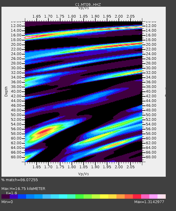
| Estimated Moho Depth: |
16.75 km |
| Estimated Crust Vp/Vs: |
1.60 |
| Assumed Crust Vp: |
6.481 km/s |
| Estimated Crust Vs: |
4.05 km/s |
| Estimated Crust Poisson's Ratio: |
0.18 |
|
| Radial Match: |
86.07255 % |
| Radial Bump: |
400 |
| Transverse Match: |
72.28519 % |
| Transverse Bump: |
400 |
| SOD ConfigId: |
7422571 |
| Insert Time: |
2019-04-22 16:34:07.610 +0000 |
| GWidth: |
2.5 |
| Max Bumps: |
400 |
| Tol: |
0.001 |
|

Signal To Noise
| Channel | StoN | STA | LTA |
| C1:MT09: :HHZ:20160528T09:53:35.679996Z | 31.455564 | 3.35072E-6 | 1.0652232E-7 |
| C1:MT09: :HHN:20160528T09:53:35.679996Z | 16.676657 | 1.6109423E-6 | 9.6598626E-8 |
| C1:MT09: :HHE:20160528T09:53:35.679996Z | 8.651845 | 1.5258943E-6 | 1.7636634E-7 |
| Arrivals |
| Ps | 1.7 SECOND |
| PpPs | 6.2 SECOND |
| PsPs/PpSs | 7.9 SECOND |


