You are here: Home > Network List > IU - Global Seismograph Network (GSN - IRIS/USGS) Stations List
> Station MACI Morro de la Arena, Canary Islands > Earthquake Result Viewer
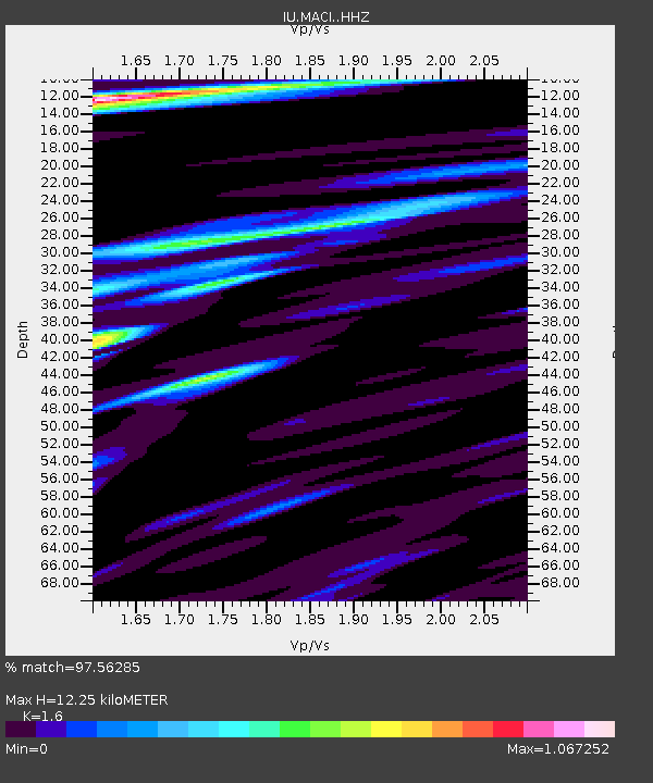
MACI Morro de la Arena, Canary Islands - Earthquake Result Viewer
| Earthquake location: |
South Sandwich Islands Region |
| Earthquake latitude/longitude: |
-56.2/-26.9 |
| Earthquake time(UTC): |
2016/05/28 (149) 09:46:59 GMT |
| Earthquake Depth: |
73 km |
| Earthquake Magnitude: |
7.2 MWW, 7.3 MI |
| Earthquake Catalog/Contributor: |
NEIC PDE/NEIC COMCAT |
|
| Network: |
IU Global Seismograph Network (GSN - IRIS/USGS) |
| Station: |
MACI Morro de la Arena, Canary Islands |
| Lat/Lon: |
28.25 N/16.51 W |
| Elevation: |
1674 m |
|
| Distance: |
84.6 deg |
| Az: |
9.191 deg |
| Baz: |
185.807 deg |
| Ray Param: |
0.045236245 |
| Estimated Moho Depth: |
12.25 km |
| Estimated Crust Vp/Vs: |
1.60 |
| Assumed Crust Vp: |
4.662 km/s |
| Estimated Crust Vs: |
2.914 km/s |
| Estimated Crust Poisson's Ratio: |
0.18 |
|
| Radial Match: |
97.56285 % |
| Radial Bump: |
277 |
| Transverse Match: |
89.332664 % |
| Transverse Bump: |
400 |
| SOD ConfigId: |
7422571 |
| Insert Time: |
2019-04-22 16:34:34.678 +0000 |
| GWidth: |
2.5 |
| Max Bumps: |
400 |
| Tol: |
0.001 |
|

Signal To Noise
| Channel | StoN | STA | LTA |
| IU:MACI: :HHZ:20160528T09:58:53.56998Z | 22.331087 | 8.996137E-6 | 4.028526E-7 |
| IU:MACI: :HHN:20160528T09:58:53.56998Z | 10.6023445 | 4.229805E-6 | 3.9895E-7 |
| IU:MACI: :HHE:20160528T09:58:53.56998Z | 3.1677635 | 1.3221255E-6 | 4.1736874E-7 |
| Arrivals |
| Ps | 1.6 SECOND |
| PpPs | 6.7 SECOND |
| PsPs/PpSs | 8.3 SECOND |


