You are here: Home > Network List > OV - Observatorio Vulcanolżgico y Sismolżgico de Costa Rica Stations List
> Station VPVF VPVF, von Frantzius > Earthquake Result Viewer
VPVF VPVF, von Frantzius - Earthquake Result Viewer
| Earthquake location: |
South Sandwich Islands Region |
| Earthquake latitude/longitude: |
-56.2/-26.9 |
| Earthquake time(UTC): |
2016/05/28 (149) 09:46:59 GMT |
| Earthquake Depth: |
73 km |
| Earthquake Magnitude: |
7.2 MWW, 7.3 MI |
| Earthquake Catalog/Contributor: |
NEIC PDE/NEIC COMCAT |
|
| Network: |
OV Observatorio Vulcanolżgico y Sismolżgico de Costa Rica |
| Station: |
VPVF VPVF, von Frantzius |
| Lat/Lon: |
10.20 N/84.23 W |
| Elevation: |
2431 m |
|
| Distance: |
81.3 deg |
| Az: |
303.037 deg |
| Baz: |
151.582 deg |
| Ray Param: |
0.047520235 |
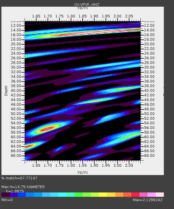
| Estimated Moho Depth: |
14.75 km |
| Estimated Crust Vp/Vs: |
1.90 |
| Assumed Crust Vp: |
6.597 km/s |
| Estimated Crust Vs: |
3.477 km/s |
| Estimated Crust Poisson's Ratio: |
0.31 |
|
| Radial Match: |
87.77187 % |
| Radial Bump: |
400 |
| Transverse Match: |
86.48727 % |
| Transverse Bump: |
400 |
| SOD ConfigId: |
7422571 |
| Insert Time: |
2019-04-22 16:35:38.167 +0000 |
| GWidth: |
2.5 |
| Max Bumps: |
400 |
| Tol: |
0.001 |
|

Signal To Noise
| Channel | StoN | STA | LTA |
| OV:VPVF: :HHZ:20160528T09:58:36.60001Z | 31.948317 | 5.8638557E-6 | 1.8354193E-7 |
| OV:VPVF: :HHN:20160528T09:58:36.60001Z | 8.299135 | 2.708708E-6 | 3.2638437E-7 |
| OV:VPVF: :HHE:20160528T09:58:36.60001Z | 5.4194603 | 2.032066E-6 | 3.7495724E-7 |
| Arrivals |
| Ps | 2.1 SECOND |
| PpPs | 6.3 SECOND |
| PsPs/PpSs | 8.4 SECOND |


