You are here: Home > Network List > PR - Puerto Rico Seismic Network (PRSN) & Puerto Rico Strong Motion Program (PRSMP) Stations List
> Station CUPR Culebra > Earthquake Result Viewer
CUPR Culebra - Earthquake Result Viewer
| Earthquake location: |
South Sandwich Islands Region |
| Earthquake latitude/longitude: |
-56.2/-26.9 |
| Earthquake time(UTC): |
2016/05/28 (149) 09:46:59 GMT |
| Earthquake Depth: |
73 km |
| Earthquake Magnitude: |
7.2 MWW, 7.3 MI |
| Earthquake Catalog/Contributor: |
NEIC PDE/NEIC COMCAT |
|
| Network: |
PR Puerto Rico Seismic Network (PRSN) & Puerto Rico Strong Motion Program (PRSMP) |
| Station: |
CUPR Culebra |
| Lat/Lon: |
18.31 N/65.28 W |
| Elevation: |
7.0 m |
|
| Distance: |
81.0 deg |
| Az: |
323.317 deg |
| Baz: |
159.427 deg |
| Ray Param: |
0.047774952 |
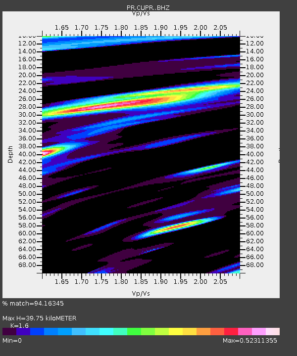
| Estimated Moho Depth: |
39.75 km |
| Estimated Crust Vp/Vs: |
1.60 |
| Assumed Crust Vp: |
5.14 km/s |
| Estimated Crust Vs: |
3.212 km/s |
| Estimated Crust Poisson's Ratio: |
0.18 |
|
| Radial Match: |
94.16345 % |
| Radial Bump: |
400 |
| Transverse Match: |
91.076454 % |
| Transverse Bump: |
400 |
| SOD ConfigId: |
7422571 |
| Insert Time: |
2019-04-22 16:35:56.160 +0000 |
| GWidth: |
2.5 |
| Max Bumps: |
400 |
| Tol: |
0.001 |
|

Signal To Noise
| Channel | StoN | STA | LTA |
| PR:CUPR: :BHZ:20160528T09:58:34.774998Z | 39.947746 | 2.1019782E-6 | 5.2618194E-8 |
| PR:CUPR: :BHN:20160528T09:58:34.774998Z | 9.542842 | 3.8439626E-7 | 4.028111E-8 |
| PR:CUPR: :BHE:20160528T09:58:34.774998Z | 7.9779005 | 3.2736082E-7 | 4.1033456E-8 |
| Arrivals |
| Ps | 4.7 SECOND |
| PpPs | 20 SECOND |
| PsPs/PpSs | 24 SECOND |


