You are here: Home > Network List > US - United States National Seismic Network Stations List
> Station BW06 Boulder Array Site 6 (Pinedale), Wyoming, USA > Earthquake Result Viewer
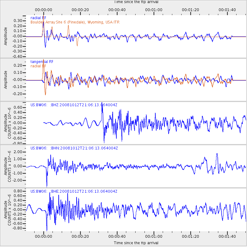
BW06 Boulder Array Site 6 (Pinedale), Wyoming, USA - Earthquake Result Viewer
*The percent match for this event was below the threshold and hence no stack was calculated.
| Earthquake location: |
Southern Bolivia |
| Earthquake latitude/longitude: |
-20.1/-65.0 |
| Earthquake time(UTC): |
2008/10/12 (286) 20:55:41 GMT |
| Earthquake Depth: |
353 km |
| Earthquake Magnitude: |
6.0 MB, 6.2 MW, 6.2 MW |
| Earthquake Catalog/Contributor: |
WHDF/NEIC |
|
| Network: |
US United States National Seismic Network |
| Station: |
BW06 Boulder Array Site 6 (Pinedale), Wyoming, USA |
| Lat/Lon: |
42.77 N/109.56 W |
| Elevation: |
2224 m |
|
| Distance: |
74.8 deg |
| Az: |
327.617 deg |
| Baz: |
136.888 deg |
| Ray Param: |
$rayparam |
*The percent match for this event was below the threshold and hence was not used in the summary stack. |
|
| Radial Match: |
66.184845 % |
| Radial Bump: |
400 |
| Transverse Match: |
62.025944 % |
| Transverse Bump: |
400 |
| SOD ConfigId: |
2556 |
| Insert Time: |
2010-03-05 03:48:56.813 +0000 |
| GWidth: |
2.5 |
| Max Bumps: |
400 |
| Tol: |
0.001 |
|
Signal To Noise
| Channel | StoN | STA | LTA |
| US:BW06: :BHN:20081012T21:06:13.064004Z | 5.9357686 | 7.567603E-7 | 1.2749155E-7 |
| US:BW06: :BHE:20081012T21:06:13.064004Z | 2.743277 | 2.8213216E-7 | 1.0284494E-7 |
| US:BW06: :BHZ:20081012T21:06:13.064004Z | 4.5130196 | 2.9546595E-7 | 6.5469685E-8 |
| Arrivals |
| Ps | |
| PpPs | |
| PsPs/PpSs | |


