You are here: Home > Network List > YT07 - POLENET Stations List
> Station MA05 Polenet mini-array MA05 > Earthquake Result Viewer
MA05 Polenet mini-array MA05 - Earthquake Result Viewer
| Earthquake location: |
South Sandwich Islands Region |
| Earthquake latitude/longitude: |
-56.2/-26.9 |
| Earthquake time(UTC): |
2016/05/28 (149) 09:46:59 GMT |
| Earthquake Depth: |
73 km |
| Earthquake Magnitude: |
7.2 MWW, 7.3 MI |
| Earthquake Catalog/Contributor: |
NEIC PDE/NEIC COMCAT |
|
| Network: |
YT POLENET |
| Station: |
MA05 Polenet mini-array MA05 |
| Lat/Lon: |
78.94 S/97.56 W |
| Elevation: |
1865 m |
|
| Distance: |
31.9 deg |
| Az: |
200.197 deg |
| Baz: |
87.674 deg |
| Ray Param: |
0.078725554 |
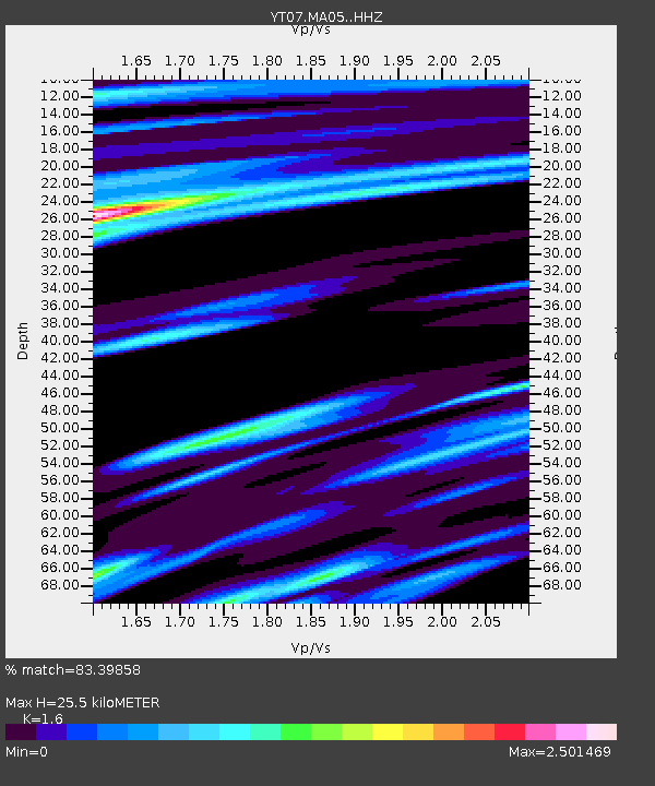
| Estimated Moho Depth: |
25.5 km |
| Estimated Crust Vp/Vs: |
1.60 |
| Assumed Crust Vp: |
5.833 km/s |
| Estimated Crust Vs: |
3.646 km/s |
| Estimated Crust Poisson's Ratio: |
0.18 |
|
| Radial Match: |
83.39858 % |
| Radial Bump: |
391 |
| Transverse Match: |
88.19915 % |
| Transverse Bump: |
320 |
| SOD ConfigId: |
7422571 |
| Insert Time: |
2019-04-22 16:37:11.378 +0000 |
| GWidth: |
2.5 |
| Max Bumps: |
400 |
| Tol: |
0.001 |
|

Signal To Noise
| Channel | StoN | STA | LTA |
| YT:MA05: :HHZ:20160528T09:52:46.739994Z | 57.079338 | 1.9518075E-5 | 3.4194642E-7 |
| YT:MA05: :HHN:20160528T09:52:46.739994Z | 4.3672156 | 9.624197E-7 | 2.2037375E-7 |
| YT:MA05: :HHE:20160528T09:52:46.739994Z | 50.704983 | 9.70669E-6 | 1.9143464E-7 |
| Arrivals |
| Ps | 2.8 SECOND |
| PpPs | 11 SECOND |
| PsPs/PpSs | 13 SECOND |


