You are here: Home > Network List > AV - Alaska Volcano Observatory Stations List
> Station MAPS Pakushin Southeast, Makushin Volcano, Alaska > Earthquake Result Viewer
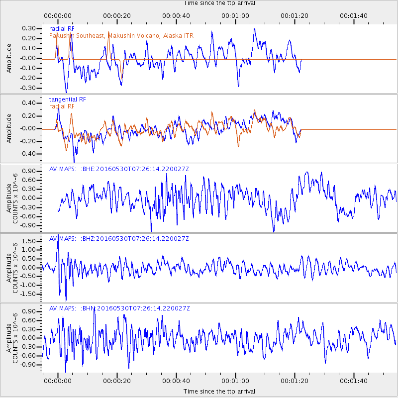
MAPS Pakushin Southeast, Makushin Volcano, Alaska - Earthquake Result Viewer
*The percent match for this event was below the threshold and hence no stack was calculated.
| Earthquake location: |
Kermadec Islands, New Zealand |
| Earthquake latitude/longitude: |
-30.4/-177.9 |
| Earthquake time(UTC): |
2016/05/30 (151) 07:14:16 GMT |
| Earthquake Depth: |
32 km |
| Earthquake Magnitude: |
5.7 MWB |
| Earthquake Catalog/Contributor: |
NEIC PDE/NEIC COMCAT |
|
| Network: |
AV Alaska Volcano Observatory |
| Station: |
MAPS Pakushin Southeast, Makushin Volcano, Alaska |
| Lat/Lon: |
53.81 N/166.94 W |
| Elevation: |
333 m |
|
| Distance: |
84.4 deg |
| Az: |
6.529 deg |
| Baz: |
189.537 deg |
| Ray Param: |
$rayparam |
*The percent match for this event was below the threshold and hence was not used in the summary stack. |
|
| Radial Match: |
46.59866 % |
| Radial Bump: |
400 |
| Transverse Match: |
70.46429 % |
| Transverse Bump: |
400 |
| SOD ConfigId: |
7422571 |
| Insert Time: |
2019-04-22 16:39:50.323 +0000 |
| GWidth: |
2.5 |
| Max Bumps: |
400 |
| Tol: |
0.001 |
|
Signal To Noise
| Channel | StoN | STA | LTA |
| AV:MAPS: :BHZ:20160530T07:26:14.220027Z | 3.5578594 | 8.5733296E-7 | 2.4096875E-7 |
| AV:MAPS: :BHN:20160530T07:26:14.220027Z | 2.2634194 | 4.825511E-7 | 2.1319563E-7 |
| AV:MAPS: :BHE:20160530T07:26:14.220027Z | 1.680839 | 4.3768654E-7 | 2.6039766E-7 |
| Arrivals |
| Ps | |
| PpPs | |
| PsPs/PpSs | |


