You are here: Home > Network List > US - United States National Seismic Network Stations List
> Station BW06 Boulder Array Site 6 (Pinedale), Wyoming, USA > Earthquake Result Viewer
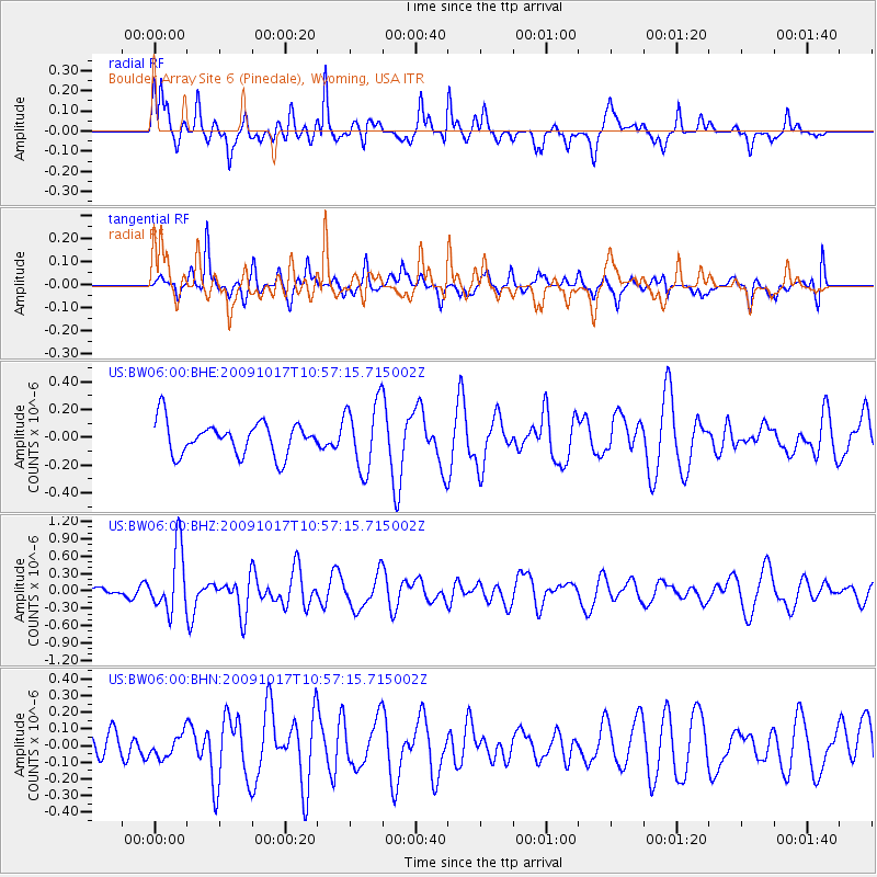
BW06 Boulder Array Site 6 (Pinedale), Wyoming, USA - Earthquake Result Viewer
*The percent match for this event was below the threshold and hence no stack was calculated.
| Earthquake location: |
Samoa Islands Region |
| Earthquake latitude/longitude: |
-16.4/-172.0 |
| Earthquake time(UTC): |
2009/10/17 (290) 10:45:26 GMT |
| Earthquake Depth: |
10 km |
| Earthquake Magnitude: |
5.7 MB, 5.3 MS, 5.7 MW, 5.7 MW |
| Earthquake Catalog/Contributor: |
WHDF/NEIC |
|
| Network: |
US United States National Seismic Network |
| Station: |
BW06 Boulder Array Site 6 (Pinedale), Wyoming, USA |
| Lat/Lon: |
42.77 N/109.56 W |
| Elevation: |
2224 m |
|
| Distance: |
82.1 deg |
| Az: |
41.227 deg |
| Baz: |
239.223 deg |
| Ray Param: |
$rayparam |
*The percent match for this event was below the threshold and hence was not used in the summary stack. |
|
| Radial Match: |
73.0139 % |
| Radial Bump: |
373 |
| Transverse Match: |
53.205093 % |
| Transverse Bump: |
357 |
| SOD ConfigId: |
2622 |
| Insert Time: |
2010-03-05 03:50:43.297 +0000 |
| GWidth: |
2.5 |
| Max Bumps: |
400 |
| Tol: |
0.001 |
|
Signal To Noise
| Channel | StoN | STA | LTA |
| US:BW06:00:BHZ:20091017T10:57:15.715002Z | 3.9465346 | 5.405861E-7 | 1.369774E-7 |
| US:BW06:00:BHN:20091017T10:57:15.715002Z | 1.111411 | 6.917656E-8 | 6.224211E-8 |
| US:BW06:00:BHE:20091017T10:57:15.715002Z | 2.0652838 | 2.4311535E-7 | 1.1771524E-7 |
| Arrivals |
| Ps | |
| PpPs | |
| PsPs/PpSs | |


