You are here: Home > Network List > US - United States National Seismic Network Stations List
> Station HAWA Hanford, Washington, USA > Earthquake Result Viewer
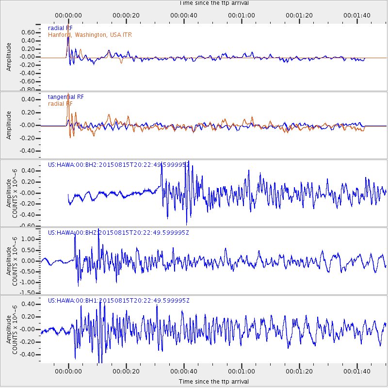
HAWA Hanford, Washington, USA - Earthquake Result Viewer
*The percent match for this event was below the threshold and hence no stack was calculated.
| Earthquake location: |
Andreanof Islands, Aleutian Is. |
| Earthquake latitude/longitude: |
51.7/-175.2 |
| Earthquake time(UTC): |
2015/08/15 (227) 20:16:21 GMT |
| Earthquake Depth: |
32 km |
| Earthquake Magnitude: |
5.6 MWB, 5.5 MI, 5.6 ML, 5.6 MWC |
| Earthquake Catalog/Contributor: |
NEIC PDE/NEIC COMCAT |
|
| Network: |
US United States National Seismic Network |
| Station: |
HAWA Hanford, Washington, USA |
| Lat/Lon: |
46.39 N/119.53 W |
| Elevation: |
364 m |
|
| Distance: |
36.1 deg |
| Az: |
75.88 deg |
| Baz: |
299.244 deg |
| Ray Param: |
$rayparam |
*The percent match for this event was below the threshold and hence was not used in the summary stack. |
|
| Radial Match: |
67.53248 % |
| Radial Bump: |
400 |
| Transverse Match: |
46.179806 % |
| Transverse Bump: |
400 |
| SOD ConfigId: |
1085051 |
| Insert Time: |
2015-09-12 00:39:57.403 +0000 |
| GWidth: |
2.5 |
| Max Bumps: |
400 |
| Tol: |
0.001 |
|
Signal To Noise
| Channel | StoN | STA | LTA |
| US:HAWA:00:BHZ:20150815T20:22:49.599995Z | 4.7028217 | 4.4705985E-7 | 9.506204E-8 |
| US:HAWA:00:BH1:20150815T20:22:49.599995Z | 2.9207122 | 1.6469745E-7 | 5.6389485E-8 |
| US:HAWA:00:BH2:20150815T20:22:49.599995Z | 3.9775088 | 2.099129E-7 | 5.2774965E-8 |
| Arrivals |
| Ps | |
| PpPs | |
| PsPs/PpSs | |


