You are here: Home > Network List > TA - USArray Transportable Network (new EarthScope stations) Stations List
> Station R11A Troy Canyon, Currant, NV, USA > Earthquake Result Viewer
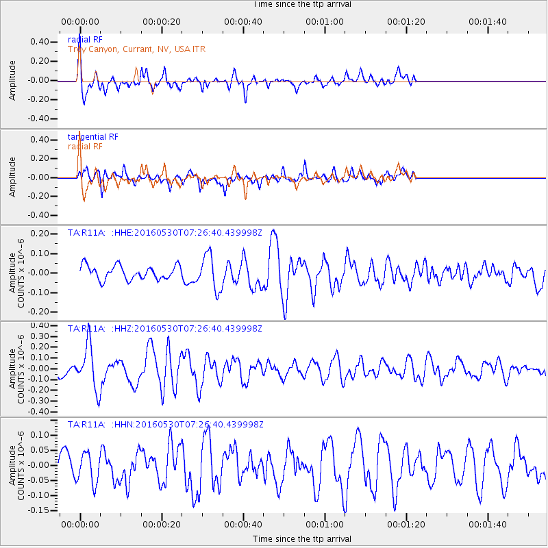
R11A Troy Canyon, Currant, NV, USA - Earthquake Result Viewer
*The percent match for this event was below the threshold and hence no stack was calculated.
| Earthquake location: |
Kermadec Islands, New Zealand |
| Earthquake latitude/longitude: |
-30.4/-177.9 |
| Earthquake time(UTC): |
2016/05/30 (151) 07:14:16 GMT |
| Earthquake Depth: |
32 km |
| Earthquake Magnitude: |
5.7 MWB |
| Earthquake Catalog/Contributor: |
NEIC PDE/NEIC COMCAT |
|
| Network: |
TA USArray Transportable Network (new EarthScope stations) |
| Station: |
R11A Troy Canyon, Currant, NV, USA |
| Lat/Lon: |
38.35 N/115.59 W |
| Elevation: |
1756 m |
|
| Distance: |
89.8 deg |
| Az: |
44.148 deg |
| Baz: |
229.952 deg |
| Ray Param: |
$rayparam |
*The percent match for this event was below the threshold and hence was not used in the summary stack. |
|
| Radial Match: |
67.38731 % |
| Radial Bump: |
400 |
| Transverse Match: |
59.09407 % |
| Transverse Bump: |
400 |
| SOD ConfigId: |
7422571 |
| Insert Time: |
2019-04-22 16:44:33.233 +0000 |
| GWidth: |
2.5 |
| Max Bumps: |
400 |
| Tol: |
0.001 |
|
Signal To Noise
| Channel | StoN | STA | LTA |
| TA:R11A: :HHZ:20160530T07:26:40.439998Z | 3.1372797 | 2.105374E-7 | 6.710827E-8 |
| TA:R11A: :HHN:20160530T07:26:40.439998Z | 1.1213742 | 4.9846417E-8 | 4.4451188E-8 |
| TA:R11A: :HHE:20160530T07:26:40.439998Z | 2.6151454 | 9.216204E-8 | 3.524165E-8 |
| Arrivals |
| Ps | |
| PpPs | |
| PsPs/PpSs | |


