You are here: Home > Network List > US - United States National Seismic Network Stations List
> Station MSO Missoula, Montana, USA > Earthquake Result Viewer
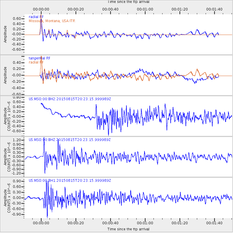
MSO Missoula, Montana, USA - Earthquake Result Viewer
*The percent match for this event was below the threshold and hence no stack was calculated.
| Earthquake location: |
Andreanof Islands, Aleutian Is. |
| Earthquake latitude/longitude: |
51.7/-175.2 |
| Earthquake time(UTC): |
2015/08/15 (227) 20:16:21 GMT |
| Earthquake Depth: |
32 km |
| Earthquake Magnitude: |
5.6 MWB, 5.5 MI, 5.6 ML, 5.6 MWC |
| Earthquake Catalog/Contributor: |
NEIC PDE/NEIC COMCAT |
|
| Network: |
US United States National Seismic Network |
| Station: |
MSO Missoula, Montana, USA |
| Lat/Lon: |
46.83 N/113.94 W |
| Elevation: |
1264 m |
|
| Distance: |
39.2 deg |
| Az: |
72.126 deg |
| Baz: |
300.323 deg |
| Ray Param: |
$rayparam |
*The percent match for this event was below the threshold and hence was not used in the summary stack. |
|
| Radial Match: |
70.65776 % |
| Radial Bump: |
400 |
| Transverse Match: |
27.30033 % |
| Transverse Bump: |
400 |
| SOD ConfigId: |
1085051 |
| Insert Time: |
2015-09-12 00:41:24.779 +0000 |
| GWidth: |
2.5 |
| Max Bumps: |
400 |
| Tol: |
0.001 |
|
Signal To Noise
| Channel | StoN | STA | LTA |
| US:MSO:00:BHZ:20150815T20:23:15.999989Z | 7.7838383 | 4.8149775E-7 | 6.185866E-8 |
| US:MSO:00:BH1:20150815T20:23:15.999989Z | 3.4452794 | 4.3081167E-7 | 1.2504405E-7 |
| US:MSO:00:BH2:20150815T20:23:15.999989Z | 1.9913896 | 3.06794E-7 | 1.5406026E-7 |
| Arrivals |
| Ps | |
| PpPs | |
| PsPs/PpSs | |


