You are here: Home > Network List > US - United States National Seismic Network Stations List
> Station BW06 Boulder Array Site 6 (Pinedale), Wyoming, USA > Earthquake Result Viewer
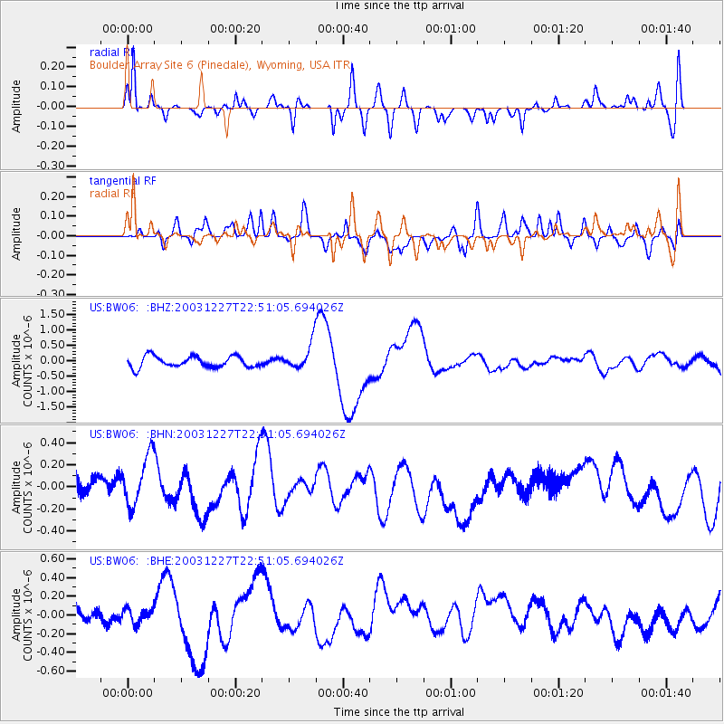
BW06 Boulder Array Site 6 (Pinedale), Wyoming, USA - Earthquake Result Viewer
*The percent match for this event was below the threshold and hence no stack was calculated.
| Earthquake location: |
Southeast Of Loyalty Islands |
| Earthquake latitude/longitude: |
-21.7/169.8 |
| Earthquake time(UTC): |
2003/12/27 (361) 22:38:01 GMT |
| Earthquake Depth: |
10 km |
| Earthquake Magnitude: |
5.8 MB, 6.7 MS, 6.7 MW, 6.7 MW |
| Earthquake Catalog/Contributor: |
WHDF/NEIC |
|
| Network: |
US United States National Seismic Network |
| Station: |
BW06 Boulder Array Site 6 (Pinedale), Wyoming, USA |
| Lat/Lon: |
42.77 N/109.56 W |
| Elevation: |
2224 m |
|
| Distance: |
97.9 deg |
| Az: |
47.172 deg |
| Baz: |
247.876 deg |
| Ray Param: |
$rayparam |
*The percent match for this event was below the threshold and hence was not used in the summary stack. |
|
| Radial Match: |
80.63791 % |
| Radial Bump: |
400 |
| Transverse Match: |
62.60874 % |
| Transverse Bump: |
400 |
| SOD ConfigId: |
110177 |
| Insert Time: |
2010-03-05 03:53:11.321 +0000 |
| GWidth: |
2.5 |
| Max Bumps: |
400 |
| Tol: |
0.001 |
|
Signal To Noise
| Channel | StoN | STA | LTA |
| US:BW06: :BHN:20031227T22:51:05.694026Z | 1.9223202 | 2.4154483E-7 | 1.2565275E-7 |
| US:BW06: :BHE:20031227T22:51:05.694026Z | 1.056284 | 8.7366956E-8 | 8.2711615E-8 |
| US:BW06: :BHZ:20031227T22:51:05.694026Z | 2.4481025 | 4.3670428E-7 | 1.783848E-7 |
| Arrivals |
| Ps | |
| PpPs | |
| PsPs/PpSs | |


