You are here: Home > Network List > US - United States National Seismic Network Stations List
> Station AHID Auburn Hatchery, Idaho, USA > Earthquake Result Viewer
AHID Auburn Hatchery, Idaho, USA - Earthquake Result Viewer

| Earthquake location: |
Near Coast Of Peru |
| Earthquake latitude/longitude: |
-17.5/-72.1 |
| Earthquake time(UTC): |
2001/07/07 (188) 09:38:43 GMT |
| Earthquake Depth: |
33 km |
| Earthquake Magnitude: |
6.6 MB, 7.3 MS, 7.6 MW, 7.5 ME |
| Earthquake Catalog/Contributor: |
WHDF/NEIC |
|
| Network: |
US United States National Seismic Network |
| Station: |
AHID Auburn Hatchery, Idaho, USA |
| Lat/Lon: |
42.77 N/111.10 W |
| Elevation: |
1960 m |
|
| Distance: |
69.9 deg |
| Az: |
330.42 deg |
| Baz: |
140.242 deg |
| Ray Param: |
0.05526875 |
| Estimated Moho Depth: |
27.25 km |
| Estimated Crust Vp/Vs: |
2.10 |
| Assumed Crust Vp: |
6.207 km/s |
| Estimated Crust Vs: |
2.959 km/s |
| Estimated Crust Poisson's Ratio: |
0.35 |
|
| Radial Match: |
95.05423 % |
| Radial Bump: |
400 |
| Transverse Match: |
88.82101 % |
| Transverse Bump: |
400 |
| SOD ConfigId: |
110165 |
| Insert Time: |
2010-03-05 03:54:49.299 +0000 |
| GWidth: |
2.5 |
| Max Bumps: |
400 |
| Tol: |
0.001 |
|
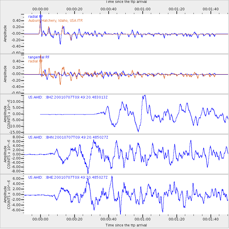
Signal To Noise
| Channel | StoN | STA | LTA |
| US:AHID: :BHN:20010707T09:49:20.485027Z | 2.5470033 | 1.6711697E-7 | 6.561317E-8 |
| US:AHID: :BHE:20010707T09:49:20.485027Z | 1.6460683 | 1.1207372E-7 | 6.8085704E-8 |
| US:AHID: :BHZ:20010707T09:49:20.483013Z | 10.808652 | 4.7202246E-7 | 4.36708E-8 |
| Arrivals |
| Ps | 5.0 SECOND |
| PpPs | 13 SECOND |
| PsPs/PpSs | 18 SECOND |


