You are here: Home > Network List > US - United States National Seismic Network Stations List
> Station AHID Auburn Hatchery, Idaho, USA > Earthquake Result Viewer
AHID Auburn Hatchery, Idaho, USA - Earthquake Result Viewer
| Earthquake location: |
South Of Fiji Islands |
| Earthquake latitude/longitude: |
-23.6/178.5 |
| Earthquake time(UTC): |
2002/08/19 (231) 11:03:13 GMT |
| Earthquake Depth: |
650 km |
| Earthquake Magnitude: |
5.9 MB |
| Earthquake Catalog/Contributor: |
WHDF/NEIC |
|
| Network: |
US United States National Seismic Network |
| Station: |
AHID Auburn Hatchery, Idaho, USA |
| Lat/Lon: |
42.77 N/111.10 W |
| Elevation: |
1960 m |
|
| Distance: |
92.4 deg |
| Az: |
43.961 deg |
| Baz: |
239.875 deg |
| Ray Param: |
0.040915594 |
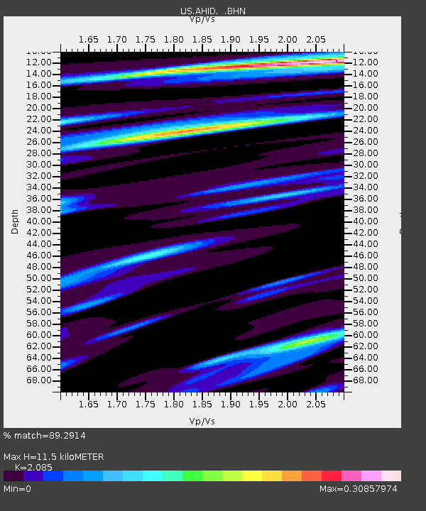
| Estimated Moho Depth: |
11.5 km |
| Estimated Crust Vp/Vs: |
2.09 |
| Assumed Crust Vp: |
6.207 km/s |
| Estimated Crust Vs: |
2.977 km/s |
| Estimated Crust Poisson's Ratio: |
0.35 |
|
| Radial Match: |
89.2914 % |
| Radial Bump: |
400 |
| Transverse Match: |
89.47699 % |
| Transverse Bump: |
400 |
| SOD ConfigId: |
110177 |
| Insert Time: |
2010-03-05 03:55:39.954 +0000 |
| GWidth: |
2.5 |
| Max Bumps: |
400 |
| Tol: |
0.001 |
|
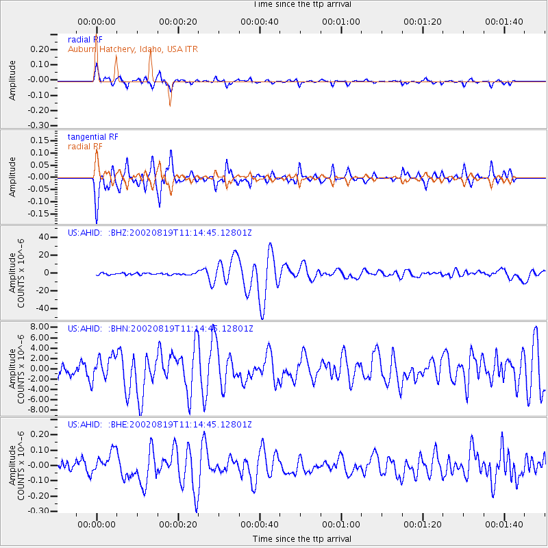
Signal To Noise
| Channel | StoN | STA | LTA |
| US:AHID: :BHN:20020819T11:14:45.12801Z | 2.4034097 | 2.1170747E-6 | 8.8086296E-7 |
| US:AHID: :BHE:20020819T11:14:45.12801Z | 2.6984706 | 7.565865E-8 | 2.80376E-8 |
| US:AHID: :BHZ:20020819T11:14:45.12801Z | 15.34823 | 1.5168877E-5 | 9.883145E-7 |
| Arrivals |
| Ps | 2.0 SECOND |
| PpPs | 5.6 SECOND |
| PsPs/PpSs | 7.7 SECOND |


