You are here: Home > Network List > KR - Kyrgyz Digital Network Stations List
> Station KDJ Kadji-Say, Kyrgyzstan > Earthquake Result Viewer
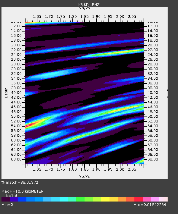
KDJ Kadji-Say, Kyrgyzstan - Earthquake Result Viewer
| Earthquake location: |
Taiwan Region |
| Earthquake latitude/longitude: |
25.6/122.5 |
| Earthquake time(UTC): |
2016/05/31 (152) 05:23:47 GMT |
| Earthquake Depth: |
243 km |
| Earthquake Magnitude: |
6.1 MO |
| Earthquake Catalog/Contributor: |
NEIC PDE/NEIC ALERT |
|
| Network: |
KR Kyrgyz Digital Network |
| Station: |
KDJ Kadji-Say, Kyrgyzstan |
| Lat/Lon: |
42.12 N/77.18 E |
| Elevation: |
1830 m |
|
| Distance: |
40.6 deg |
| Az: |
305.611 deg |
| Baz: |
99.27 deg |
| Ray Param: |
0.07331124 |
| Estimated Moho Depth: |
10.0 km |
| Estimated Crust Vp/Vs: |
1.60 |
| Assumed Crust Vp: |
6.306 km/s |
| Estimated Crust Vs: |
3.941 km/s |
| Estimated Crust Poisson's Ratio: |
0.18 |
|
| Radial Match: |
88.61372 % |
| Radial Bump: |
400 |
| Transverse Match: |
86.568474 % |
| Transverse Bump: |
400 |
| SOD ConfigId: |
7422571 |
| Insert Time: |
2019-04-22 16:52:00.817 +0000 |
| GWidth: |
2.5 |
| Max Bumps: |
400 |
| Tol: |
0.001 |
|

Signal To Noise
| Channel | StoN | STA | LTA |
| KR:KDJ: :BHZ:20160531T05:30:32.799988Z | 17.324997 | 8.319459E-7 | 4.801997E-8 |
| KR:KDJ: :BHN:20160531T05:30:32.799988Z | 5.3009214 | 2.1995443E-7 | 4.149362E-8 |
| KR:KDJ: :BHE:20160531T05:30:32.799988Z | 14.145534 | 3.799539E-7 | 2.6860343E-8 |
| Arrivals |
| Ps | 1.0 SECOND |
| PpPs | 3.8 SECOND |
| PsPs/PpSs | 4.9 SECOND |


