AHID Auburn Hatchery, Idaho, USA - Earthquake Result Viewer
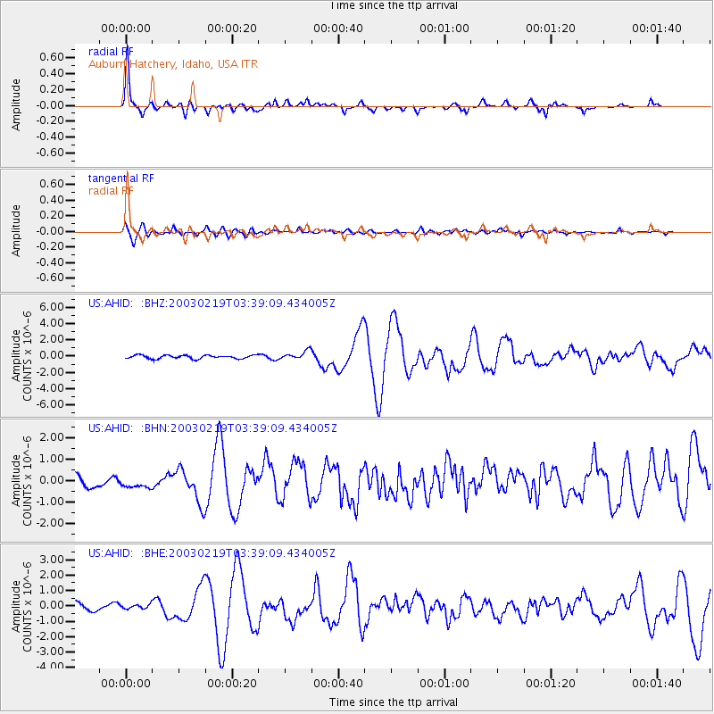
Earthquake location: Unimak Island Region, Alaska
Earthquake latitude/longitude: 53.6/-164.6
Earthquake time(UTC): 2003/02/19 (050) 03:32:36 GMT
Earthquake Depth: 19 km
Earthquake Magnitude: 5.8 MB, 6.6 MS, 6.6 MW, 6.6 MW
Earthquake Catalog/Contributor: WHDF/NEIC
Network: US United States National Seismic Network
Station: AHID Auburn Hatchery, Idaho, USA
Lat/Lon: 42.77 N/111.10 W
Elevation: 1960 m
Distance: 36.5 deg
Az: 85.059 deg
Baz: 306.344 deg
Ray Param: 0.07663731
Estimated Moho Depth: 64.5 km
Estimated Crust Vp/Vs: 2.10
Assumed Crust Vp: 6.207 km/s
Estimated Crust Vs: 2.959 km/s
Estimated Crust Poisson's Ratio: 0.35
Radial Match: 93.0172 %
Radial Bump: 393
Transverse Match: 69.72111 %
Transverse Bump: 400
SOD ConfigId: 110177
Insert Time: 2010-03-05 03:56:00.070 +0000
GWidth: 2.5
Max Bumps: 400
Tol: 0.001

Signal To Noise

ChannelStoNSTALTA
US:AHID: :BHN:20030219T03:39:09.434005Z0.55958491.738571E-73.1068942E-7
US:AHID: :BHE:20030219T03:39:09.434005Z0.4556191.4037907E-73.0810625E-7
US:AHID: :BHZ:20030219T03:39:09.434005Z2.4340935.250515E-72.1570725E-7
Arrivals
Ps12 SECOND
PpPs30 SECOND
PsPs/PpSs42 SECOND