You are here: Home > Network List > NY - Yukon Northwest Seismic Network(YNSN) Stations List
> Station MMPY Sheldon Lake, Yukon, CANADA > Earthquake Result Viewer
MMPY Sheldon Lake, Yukon, CANADA - Earthquake Result Viewer
| Earthquake location: |
Taiwan Region |
| Earthquake latitude/longitude: |
25.6/122.5 |
| Earthquake time(UTC): |
2016/05/31 (152) 05:23:47 GMT |
| Earthquake Depth: |
243 km |
| Earthquake Magnitude: |
6.1 MO |
| Earthquake Catalog/Contributor: |
NEIC PDE/NEIC ALERT |
|
| Network: |
NY Yukon Northwest Seismic Network(YNSN) |
| Station: |
MMPY Sheldon Lake, Yukon, CANADA |
| Lat/Lon: |
62.62 N/131.26 W |
| Elevation: |
0.0 m |
|
| Distance: |
74.7 deg |
| Az: |
27.404 deg |
| Baz: |
295.959 deg |
| Ray Param: |
0.051506843 |
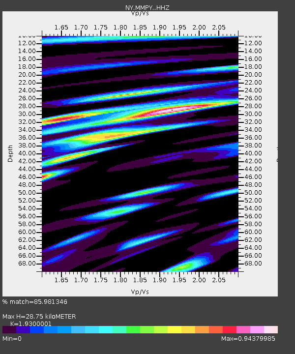
| Estimated Moho Depth: |
28.75 km |
| Estimated Crust Vp/Vs: |
1.93 |
| Assumed Crust Vp: |
6.419 km/s |
| Estimated Crust Vs: |
3.326 km/s |
| Estimated Crust Poisson's Ratio: |
0.32 |
|
| Radial Match: |
85.981346 % |
| Radial Bump: |
400 |
| Transverse Match: |
75.632225 % |
| Transverse Bump: |
400 |
| SOD ConfigId: |
7422571 |
| Insert Time: |
2019-04-22 16:52:55.609 +0000 |
| GWidth: |
2.5 |
| Max Bumps: |
400 |
| Tol: |
0.001 |
|

Signal To Noise
| Channel | StoN | STA | LTA |
| NY:MMPY: :HHZ:20160531T05:34:28.820007Z | 14.429384 | 6.558841E-7 | 4.5454755E-8 |
| NY:MMPY: :HHN:20160531T05:34:28.820007Z | 2.6295881 | 7.0545E-8 | 2.6827395E-8 |
| NY:MMPY: :HHE:20160531T05:34:28.820007Z | 5.9160604 | 2.3558296E-7 | 3.9820918E-8 |
| Arrivals |
| Ps | 4.3 SECOND |
| PpPs | 13 SECOND |
| PsPs/PpSs | 17 SECOND |


