You are here: Home > Network List > TA - USArray Transportable Network (new EarthScope stations) Stations List
> Station H24K Noodor Dome, AK, USA > Earthquake Result Viewer
H24K Noodor Dome, AK, USA - Earthquake Result Viewer

| Earthquake location: |
Taiwan Region |
| Earthquake latitude/longitude: |
25.6/122.5 |
| Earthquake time(UTC): |
2016/05/31 (152) 05:23:47 GMT |
| Earthquake Depth: |
243 km |
| Earthquake Magnitude: |
6.1 MO |
| Earthquake Catalog/Contributor: |
NEIC PDE/NEIC ALERT |
|
| Network: |
TA USArray Transportable Network (new EarthScope stations) |
| Station: |
H24K Noodor Dome, AK, USA |
| Lat/Lon: |
65.84 N/147.88 W |
| Elevation: |
814 m |
|
| Distance: |
66.8 deg |
| Az: |
26.602 deg |
| Baz: |
280.724 deg |
| Ray Param: |
0.05664287 |
| Estimated Moho Depth: |
28.25 km |
| Estimated Crust Vp/Vs: |
1.70 |
| Assumed Crust Vp: |
6.566 km/s |
| Estimated Crust Vs: |
3.857 km/s |
| Estimated Crust Poisson's Ratio: |
0.24 |
|
| Radial Match: |
90.5346 % |
| Radial Bump: |
400 |
| Transverse Match: |
77.56904 % |
| Transverse Bump: |
400 |
| SOD ConfigId: |
7422571 |
| Insert Time: |
2019-04-22 16:54:00.601 +0000 |
| GWidth: |
2.5 |
| Max Bumps: |
400 |
| Tol: |
0.001 |
|
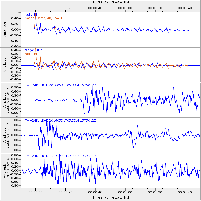
Signal To Noise
| Channel | StoN | STA | LTA |
| TA:H24K: :BHZ:20160531T05:33:41.575012Z | 16.676289 | 1.0832343E-6 | 6.495656E-8 |
| TA:H24K: :BHN:20160531T05:33:41.575012Z | 2.308235 | 1.3520206E-7 | 5.8573786E-8 |
| TA:H24K: :BHE:20160531T05:33:41.575012Z | 11.79942 | 3.8768852E-7 | 3.2856573E-8 |
| Arrivals |
| Ps | 3.2 SECOND |
| PpPs | 11 SECOND |
| PsPs/PpSs | 14 SECOND |


