You are here: Home > Network List > TA - USArray Transportable Network (new EarthScope stations) Stations List
> Station J26L Joseph Creek, AK, USA > Earthquake Result Viewer
J26L Joseph Creek, AK, USA - Earthquake Result Viewer
| Earthquake location: |
Taiwan Region |
| Earthquake latitude/longitude: |
25.6/122.5 |
| Earthquake time(UTC): |
2016/05/31 (152) 05:23:47 GMT |
| Earthquake Depth: |
243 km |
| Earthquake Magnitude: |
6.1 MO |
| Earthquake Catalog/Contributor: |
NEIC PDE/NEIC ALERT |
|
| Network: |
TA USArray Transportable Network (new EarthScope stations) |
| Station: |
J26L Joseph Creek, AK, USA |
| Lat/Lon: |
64.50 N/143.56 W |
| Elevation: |
1144 m |
|
| Distance: |
68.9 deg |
| Az: |
27.576 deg |
| Baz: |
285.003 deg |
| Ray Param: |
0.05529985 |
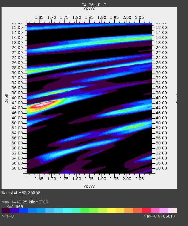
| Estimated Moho Depth: |
42.25 km |
| Estimated Crust Vp/Vs: |
1.66 |
| Assumed Crust Vp: |
6.566 km/s |
| Estimated Crust Vs: |
3.944 km/s |
| Estimated Crust Poisson's Ratio: |
0.22 |
|
| Radial Match: |
85.35558 % |
| Radial Bump: |
359 |
| Transverse Match: |
73.695145 % |
| Transverse Bump: |
400 |
| SOD ConfigId: |
7422571 |
| Insert Time: |
2019-04-22 16:54:11.315 +0000 |
| GWidth: |
2.5 |
| Max Bumps: |
400 |
| Tol: |
0.001 |
|
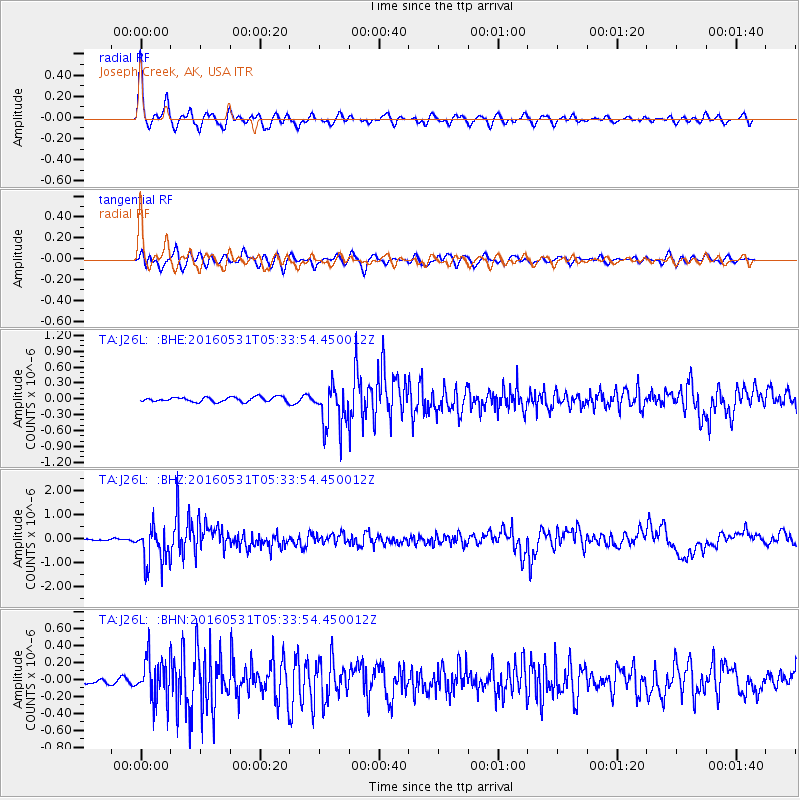
Signal To Noise
| Channel | StoN | STA | LTA |
| TA:J26L: :BHZ:20160531T05:33:54.450012Z | 22.007633 | 7.9314117E-7 | 3.6039367E-8 |
| TA:J26L: :BHN:20160531T05:33:54.450012Z | 6.5599976 | 2.4856087E-7 | 3.7890388E-8 |
| TA:J26L: :BHE:20160531T05:33:54.450012Z | 8.987532 | 3.9786957E-7 | 4.4269058E-8 |
| Arrivals |
| Ps | 4.5 SECOND |
| PpPs | 16 SECOND |
| PsPs/PpSs | 21 SECOND |


