You are here: Home > Network List > TA - USArray Transportable Network (new EarthScope stations) Stations List
> Station K20K Telida, AK, USA > Earthquake Result Viewer
K20K Telida, AK, USA - Earthquake Result Viewer
| Earthquake location: |
Taiwan Region |
| Earthquake latitude/longitude: |
25.6/122.5 |
| Earthquake time(UTC): |
2016/05/31 (152) 05:23:47 GMT |
| Earthquake Depth: |
243 km |
| Earthquake Magnitude: |
6.1 MO |
| Earthquake Catalog/Contributor: |
NEIC PDE/NEIC ALERT |
|
| Network: |
TA USArray Transportable Network (new EarthScope stations) |
| Station: |
K20K Telida, AK, USA |
| Lat/Lon: |
63.36 N/154.07 W |
| Elevation: |
548 m |
|
| Distance: |
64.5 deg |
| Az: |
29.738 deg |
| Baz: |
276.428 deg |
| Ray Param: |
0.05810877 |
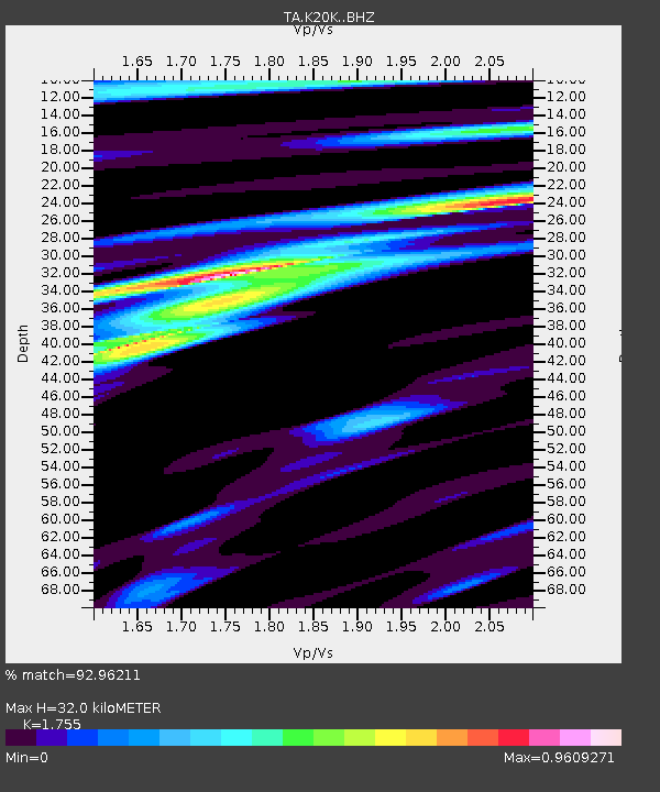
| Estimated Moho Depth: |
32.0 km |
| Estimated Crust Vp/Vs: |
1.75 |
| Assumed Crust Vp: |
6.438 km/s |
| Estimated Crust Vs: |
3.669 km/s |
| Estimated Crust Poisson's Ratio: |
0.26 |
|
| Radial Match: |
92.96211 % |
| Radial Bump: |
400 |
| Transverse Match: |
83.460014 % |
| Transverse Bump: |
400 |
| SOD ConfigId: |
7422571 |
| Insert Time: |
2019-04-22 16:54:15.270 +0000 |
| GWidth: |
2.5 |
| Max Bumps: |
400 |
| Tol: |
0.001 |
|

Signal To Noise
| Channel | StoN | STA | LTA |
| TA:K20K: :BHZ:20160531T05:33:27.150024Z | 20.458902 | 1.1403624E-6 | 5.573918E-8 |
| TA:K20K: :BHN:20160531T05:33:27.150024Z | 3.784486 | 2.1318832E-7 | 5.633217E-8 |
| TA:K20K: :BHE:20160531T05:33:27.150024Z | 6.756538 | 4.4200618E-7 | 6.541903E-8 |
| Arrivals |
| Ps | 3.9 SECOND |
| PpPs | 13 SECOND |
| PsPs/PpSs | 17 SECOND |


