You are here: Home > Network List > TA - USArray Transportable Network (new EarthScope stations) Stations List
> Station O19K Port Alsworth, AK, USA > Earthquake Result Viewer
O19K Port Alsworth, AK, USA - Earthquake Result Viewer
| Earthquake location: |
Taiwan Region |
| Earthquake latitude/longitude: |
25.6/122.5 |
| Earthquake time(UTC): |
2016/05/31 (152) 05:23:47 GMT |
| Earthquake Depth: |
243 km |
| Earthquake Magnitude: |
6.1 MO |
| Earthquake Catalog/Contributor: |
NEIC PDE/NEIC ALERT |
|
| Network: |
TA USArray Transportable Network (new EarthScope stations) |
| Station: |
O19K Port Alsworth, AK, USA |
| Lat/Lon: |
60.20 N/154.32 W |
| Elevation: |
96 m |
|
| Distance: |
64.8 deg |
| Az: |
33.239 deg |
| Baz: |
277.706 deg |
| Ray Param: |
0.05793279 |
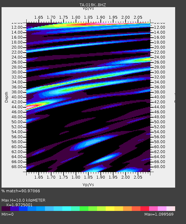
| Estimated Moho Depth: |
10.0 km |
| Estimated Crust Vp/Vs: |
1.97 |
| Assumed Crust Vp: |
6.566 km/s |
| Estimated Crust Vs: |
3.329 km/s |
| Estimated Crust Poisson's Ratio: |
0.33 |
|
| Radial Match: |
90.97866 % |
| Radial Bump: |
400 |
| Transverse Match: |
79.8077 % |
| Transverse Bump: |
400 |
| SOD ConfigId: |
7422571 |
| Insert Time: |
2019-04-22 16:54:37.683 +0000 |
| GWidth: |
2.5 |
| Max Bumps: |
400 |
| Tol: |
0.001 |
|

Signal To Noise
| Channel | StoN | STA | LTA |
| TA:O19K: :BHZ:20160531T05:33:28.900024Z | 12.757075 | 1.1768035E-6 | 9.224712E-8 |
| TA:O19K: :BHN:20160531T05:33:28.900024Z | 1.7654967 | 1.8887513E-7 | 1.069813E-7 |
| TA:O19K: :BHE:20160531T05:33:28.900024Z | 5.296789 | 5.628222E-7 | 1.0625723E-7 |
| Arrivals |
| Ps | 1.5 SECOND |
| PpPs | 4.4 SECOND |
| PsPs/PpSs | 5.9 SECOND |


