You are here: Home > Network List > US - United States National Seismic Network Stations List
> Station AMTX Amarillo, Texas, USA > Earthquake Result Viewer
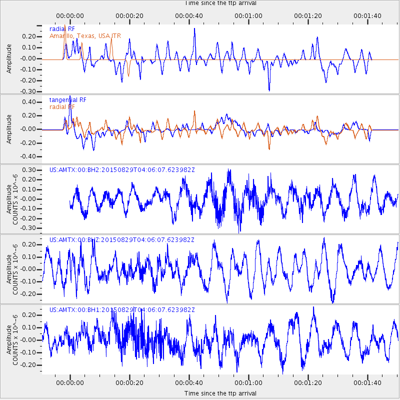
AMTX Amarillo, Texas, USA - Earthquake Result Viewer
*The percent match for this event was below the threshold and hence no stack was calculated.
| Earthquake location: |
Mariana Islands |
| Earthquake latitude/longitude: |
19.1/145.7 |
| Earthquake time(UTC): |
2015/08/29 (241) 03:53:23 GMT |
| Earthquake Depth: |
124 km |
| Earthquake Magnitude: |
5.5 MB |
| Earthquake Catalog/Contributor: |
NEIC PDE/NEIC COMCAT |
|
| Network: |
US United States National Seismic Network |
| Station: |
AMTX Amarillo, Texas, USA |
| Lat/Lon: |
34.53 N/101.41 W |
| Elevation: |
1010 m |
|
| Distance: |
96.9 deg |
| Az: |
49.989 deg |
| Baz: |
298.717 deg |
| Ray Param: |
$rayparam |
*The percent match for this event was below the threshold and hence was not used in the summary stack. |
|
| Radial Match: |
56.890373 % |
| Radial Bump: |
400 |
| Transverse Match: |
43.875244 % |
| Transverse Bump: |
400 |
| SOD ConfigId: |
1085051 |
| Insert Time: |
2015-09-12 04:09:03.250 +0000 |
| GWidth: |
2.5 |
| Max Bumps: |
400 |
| Tol: |
0.001 |
|
Signal To Noise
| Channel | StoN | STA | LTA |
| US:AMTX:00:BHZ:20150829T04:06:07.623982Z | 1.0070173 | 9.8855146E-8 | 9.816629E-8 |
| US:AMTX:00:BH1:20150829T04:06:07.623982Z | 1.3211148 | 1.0689353E-7 | 8.091161E-8 |
| US:AMTX:00:BH2:20150829T04:06:07.623982Z | 1.3181989 | 1.09301574E-7 | 8.291736E-8 |
| Arrivals |
| Ps | |
| PpPs | |
| PsPs/PpSs | |


