You are here: Home > Network List > UW - Pacific Northwest Regional Seismic Network Stations List
> Station LEBA Lebam, WA, USA > Earthquake Result Viewer
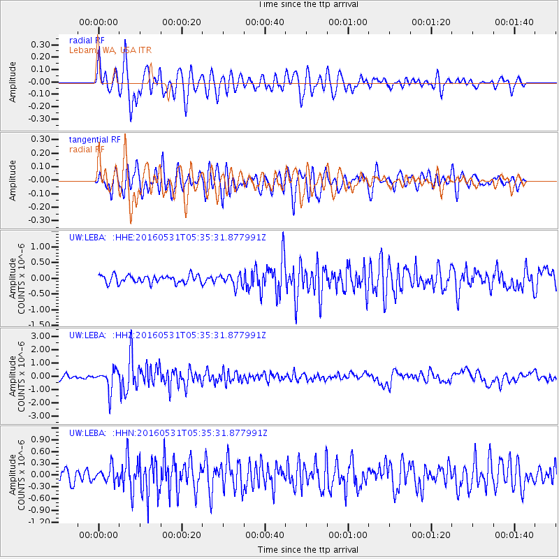
LEBA Lebam, WA, USA - Earthquake Result Viewer
*The percent match for this event was below the threshold and hence no stack was calculated.
| Earthquake location: |
Taiwan Region |
| Earthquake latitude/longitude: |
25.6/122.5 |
| Earthquake time(UTC): |
2016/05/31 (152) 05:23:47 GMT |
| Earthquake Depth: |
243 km |
| Earthquake Magnitude: |
6.1 MO |
| Earthquake Catalog/Contributor: |
NEIC PDE/NEIC ALERT |
|
| Network: |
UW Pacific Northwest Regional Seismic Network |
| Station: |
LEBA Lebam, WA, USA |
| Lat/Lon: |
46.55 N/123.56 W |
| Elevation: |
73 m |
|
| Distance: |
86.7 deg |
| Az: |
39.196 deg |
| Baz: |
304.211 deg |
| Ray Param: |
$rayparam |
*The percent match for this event was below the threshold and hence was not used in the summary stack. |
|
| Radial Match: |
79.120895 % |
| Radial Bump: |
400 |
| Transverse Match: |
73.06912 % |
| Transverse Bump: |
400 |
| SOD ConfigId: |
7422571 |
| Insert Time: |
2019-04-22 16:55:21.008 +0000 |
| GWidth: |
2.5 |
| Max Bumps: |
400 |
| Tol: |
0.001 |
|
Signal To Noise
| Channel | StoN | STA | LTA |
| UW:LEBA: :HHZ:20160531T05:35:31.877991Z | 6.7355614 | 8.0537825E-7 | 1.1957107E-7 |
| UW:LEBA: :HHN:20160531T05:35:31.877991Z | 1.3819617 | 1.8766279E-7 | 1.357945E-7 |
| UW:LEBA: :HHE:20160531T05:35:31.877991Z | 1.5961124 | 1.9900581E-7 | 1.2468158E-7 |
| Arrivals |
| Ps | |
| PpPs | |
| PsPs/PpSs | |


