You are here: Home > Network List > XD14 - Illuminating the architecture of the greater Mount St. Helens magmatic systems f Stations List
> Station MI05 "Mount St Helens, WA" > Earthquake Result Viewer
MI05 "Mount St Helens, WA" - Earthquake Result Viewer
| Earthquake location: |
Taiwan Region |
| Earthquake latitude/longitude: |
25.6/122.5 |
| Earthquake time(UTC): |
2016/05/31 (152) 05:23:47 GMT |
| Earthquake Depth: |
243 km |
| Earthquake Magnitude: |
6.1 MO |
| Earthquake Catalog/Contributor: |
NEIC PDE/NEIC ALERT |
|
| Network: |
XD Illuminating the architecture of the greater Mount St. Helens magmatic systems f |
| Station: |
MI05 "Mount St Helens, WA" |
| Lat/Lon: |
46.23 N/122.29 W |
| Elevation: |
1255 m |
|
| Distance: |
87.6 deg |
| Az: |
38.955 deg |
| Baz: |
305.116 deg |
| Ray Param: |
0.04263423 |
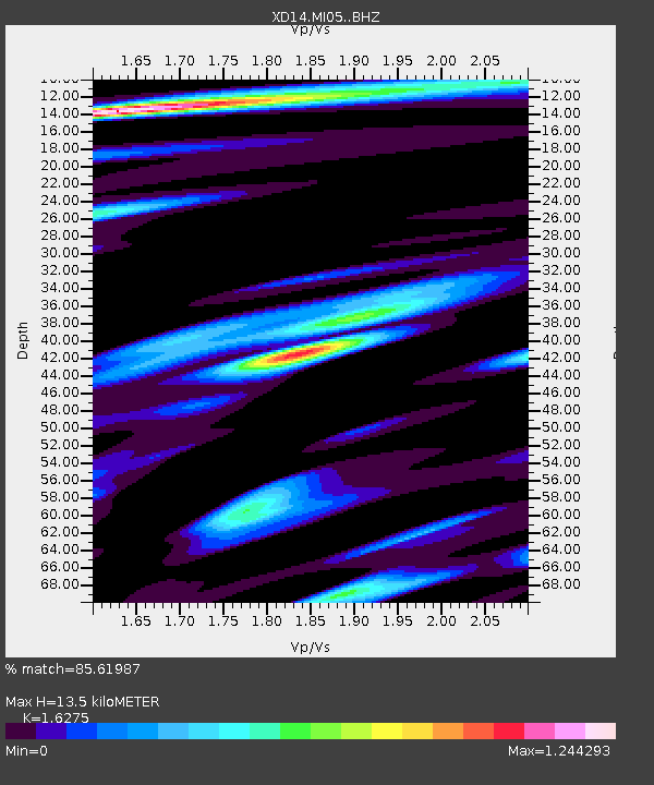
| Estimated Moho Depth: |
13.5 km |
| Estimated Crust Vp/Vs: |
1.63 |
| Assumed Crust Vp: |
6.566 km/s |
| Estimated Crust Vs: |
4.035 km/s |
| Estimated Crust Poisson's Ratio: |
0.20 |
|
| Radial Match: |
85.61987 % |
| Radial Bump: |
400 |
| Transverse Match: |
82.03128 % |
| Transverse Bump: |
400 |
| SOD ConfigId: |
7422571 |
| Insert Time: |
2019-04-22 16:56:08.077 +0000 |
| GWidth: |
2.5 |
| Max Bumps: |
400 |
| Tol: |
0.001 |
|

Signal To Noise
| Channel | StoN | STA | LTA |
| XD:MI05: :BHZ:20160531T05:35:36.184998Z | 10.256744 | 7.936824E-7 | 7.738151E-8 |
| XD:MI05: :BHN:20160531T05:35:36.184998Z | 2.7319624 | 2.2176728E-7 | 8.117509E-8 |
| XD:MI05: :BHE:20160531T05:35:36.184998Z | 2.9955664 | 2.4527776E-7 | 8.1880266E-8 |
| Arrivals |
| Ps | 1.3 SECOND |
| PpPs | 5.3 SECOND |
| PsPs/PpSs | 6.6 SECOND |


