You are here: Home > Network List > AK - Alaska Regional Network Stations List
> Station CUT Chulitna, AK, USA > Earthquake Result Viewer
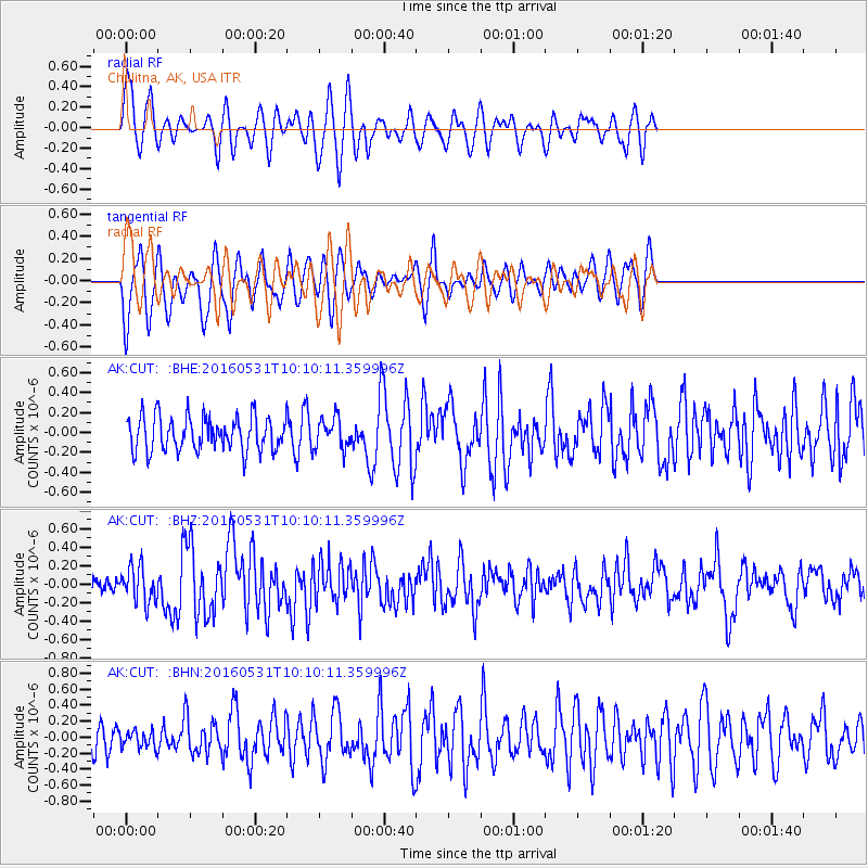
CUT Chulitna, AK, USA - Earthquake Result Viewer
*The percent match for this event was below the threshold and hence no stack was calculated.
| Earthquake location: |
Kuril Islands |
| Earthquake latitude/longitude: |
47.5/154.4 |
| Earthquake time(UTC): |
2016/05/31 (152) 10:03:59 GMT |
| Earthquake Depth: |
10 km |
| Earthquake Magnitude: |
5.5 MB |
| Earthquake Catalog/Contributor: |
NEIC PDE/NEIC COMCAT |
|
| Network: |
AK Alaska Regional Network |
| Station: |
CUT Chulitna, AK, USA |
| Lat/Lon: |
62.41 N/150.26 W |
| Elevation: |
574 m |
|
| Distance: |
33.9 deg |
| Az: |
43.424 deg |
| Baz: |
270.194 deg |
| Ray Param: |
$rayparam |
*The percent match for this event was below the threshold and hence was not used in the summary stack. |
|
| Radial Match: |
66.63061 % |
| Radial Bump: |
400 |
| Transverse Match: |
62.869564 % |
| Transverse Bump: |
400 |
| SOD ConfigId: |
7422571 |
| Insert Time: |
2019-04-22 16:58:12.289 +0000 |
| GWidth: |
2.5 |
| Max Bumps: |
400 |
| Tol: |
0.001 |
|
Signal To Noise
| Channel | StoN | STA | LTA |
| AK:CUT: :BHZ:20160531T10:10:11.359996Z | 2.0083232 | 1.9319455E-7 | 9.619694E-8 |
| AK:CUT: :BHN:20160531T10:10:11.359996Z | 0.6726226 | 1.08992E-7 | 1.6204035E-7 |
| AK:CUT: :BHE:20160531T10:10:11.359996Z | 0.85755503 | 1.4661765E-7 | 1.7097172E-7 |
| Arrivals |
| Ps | |
| PpPs | |
| PsPs/PpSs | |


