You are here: Home > Network List > CN - Canadian National Seismograph Network Stations List
> Station FRB IQALUIT, N.W.T. > Earthquake Result Viewer
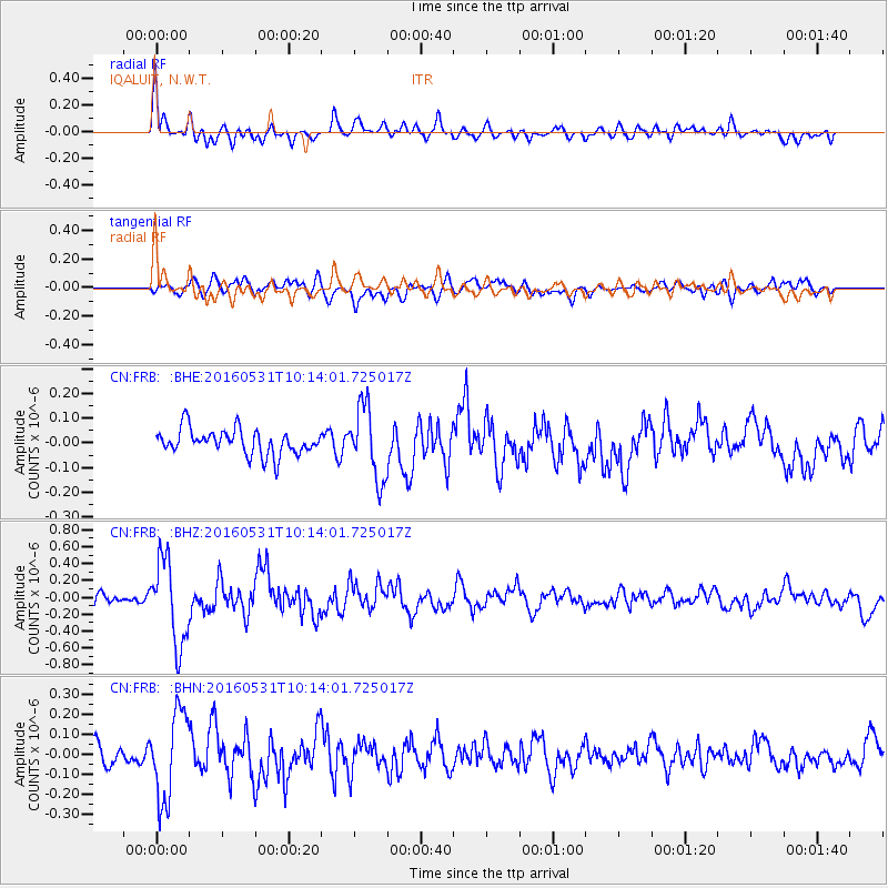
FRB IQALUIT, N.W.T. - Earthquake Result Viewer
*The percent match for this event was below the threshold and hence no stack was calculated.
| Earthquake location: |
Kuril Islands |
| Earthquake latitude/longitude: |
47.5/154.4 |
| Earthquake time(UTC): |
2016/05/31 (152) 10:03:59 GMT |
| Earthquake Depth: |
10 km |
| Earthquake Magnitude: |
5.5 MB |
| Earthquake Catalog/Contributor: |
NEIC PDE/NEIC COMCAT |
|
| Network: |
CN Canadian National Seismograph Network |
| Station: |
FRB IQALUIT, N.W.T. |
| Lat/Lon: |
63.75 N/68.55 W |
| Elevation: |
18 m |
|
| Distance: |
64.0 deg |
| Az: |
19.686 deg |
| Baz: |
329.129 deg |
| Ray Param: |
$rayparam |
*The percent match for this event was below the threshold and hence was not used in the summary stack. |
|
| Radial Match: |
76.92571 % |
| Radial Bump: |
400 |
| Transverse Match: |
61.50459 % |
| Transverse Bump: |
400 |
| SOD ConfigId: |
7422571 |
| Insert Time: |
2019-04-22 17:00:23.626 +0000 |
| GWidth: |
2.5 |
| Max Bumps: |
400 |
| Tol: |
0.001 |
|
Signal To Noise
| Channel | StoN | STA | LTA |
| CN:FRB: :BHZ:20160531T10:14:01.725017Z | 6.218594 | 4.950922E-7 | 7.961481E-8 |
| CN:FRB: :BHN:20160531T10:14:01.725017Z | 3.9562106 | 2.1618261E-7 | 5.464386E-8 |
| CN:FRB: :BHE:20160531T10:14:01.725017Z | 2.883118 | 1.4755699E-7 | 5.1179658E-8 |
| Arrivals |
| Ps | |
| PpPs | |
| PsPs/PpSs | |


