You are here: Home > Network List > TA - USArray Transportable Network (new EarthScope stations) Stations List
> Station K22A Casper, WY, USA > Earthquake Result Viewer
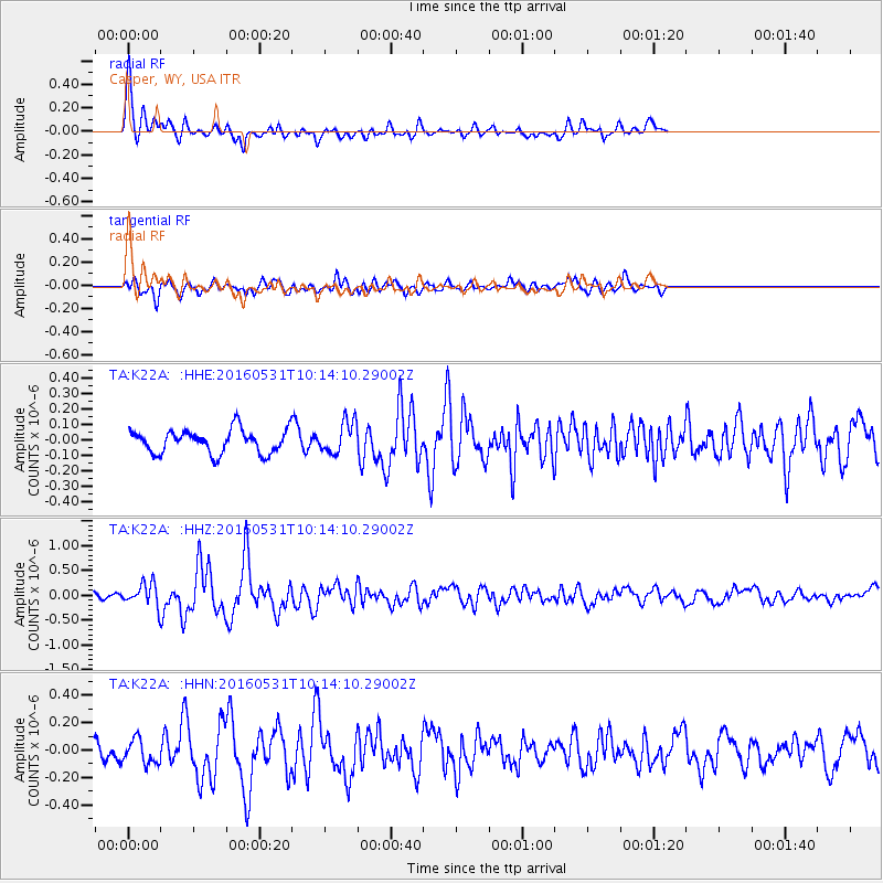
K22A Casper, WY, USA - Earthquake Result Viewer
*The percent match for this event was below the threshold and hence no stack was calculated.
| Earthquake location: |
Kuril Islands |
| Earthquake latitude/longitude: |
47.5/154.4 |
| Earthquake time(UTC): |
2016/05/31 (152) 10:03:59 GMT |
| Earthquake Depth: |
10 km |
| Earthquake Magnitude: |
5.5 MB |
| Earthquake Catalog/Contributor: |
NEIC PDE/NEIC COMCAT |
|
| Network: |
TA USArray Transportable Network (new EarthScope stations) |
| Station: |
K22A Casper, WY, USA |
| Lat/Lon: |
42.65 N/106.52 W |
| Elevation: |
1686 m |
|
| Distance: |
65.3 deg |
| Az: |
53.286 deg |
| Baz: |
312.603 deg |
| Ray Param: |
$rayparam |
*The percent match for this event was below the threshold and hence was not used in the summary stack. |
|
| Radial Match: |
77.88011 % |
| Radial Bump: |
400 |
| Transverse Match: |
68.34008 % |
| Transverse Bump: |
400 |
| SOD ConfigId: |
7422571 |
| Insert Time: |
2019-04-22 17:07:07.656 +0000 |
| GWidth: |
2.5 |
| Max Bumps: |
400 |
| Tol: |
0.001 |
|
Signal To Noise
| Channel | StoN | STA | LTA |
| TA:K22A: :HHZ:20160531T10:14:10.29002Z | 4.1656957 | 2.4233788E-7 | 5.8174646E-8 |
| TA:K22A: :HHN:20160531T10:14:10.29002Z | 1.7781014 | 8.848437E-8 | 4.97634E-8 |
| TA:K22A: :HHE:20160531T10:14:10.29002Z | 1.3412155 | 1.0441184E-7 | 7.784867E-8 |
| Arrivals |
| Ps | |
| PpPs | |
| PsPs/PpSs | |


