You are here: Home > Network List > TA - USArray Transportable Network (new EarthScope stations) Stations List
> Station MSTX Muleshoe, TX, USA > Earthquake Result Viewer
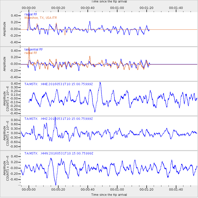
MSTX Muleshoe, TX, USA - Earthquake Result Viewer
*The percent match for this event was below the threshold and hence no stack was calculated.
| Earthquake location: |
Kuril Islands |
| Earthquake latitude/longitude: |
47.5/154.4 |
| Earthquake time(UTC): |
2016/05/31 (152) 10:03:59 GMT |
| Earthquake Depth: |
10 km |
| Earthquake Magnitude: |
5.5 MB |
| Earthquake Catalog/Contributor: |
NEIC PDE/NEIC COMCAT |
|
| Network: |
TA USArray Transportable Network (new EarthScope stations) |
| Station: |
MSTX Muleshoe, TX, USA |
| Lat/Lon: |
33.97 N/102.77 W |
| Elevation: |
1167 m |
|
| Distance: |
73.5 deg |
| Az: |
57.666 deg |
| Baz: |
316.47 deg |
| Ray Param: |
$rayparam |
*The percent match for this event was below the threshold and hence was not used in the summary stack. |
|
| Radial Match: |
64.066086 % |
| Radial Bump: |
400 |
| Transverse Match: |
64.45503 % |
| Transverse Bump: |
400 |
| SOD ConfigId: |
7422571 |
| Insert Time: |
2019-04-22 17:07:21.815 +0000 |
| GWidth: |
2.5 |
| Max Bumps: |
400 |
| Tol: |
0.001 |
|
Signal To Noise
| Channel | StoN | STA | LTA |
| TA:MSTX: :HHZ:20160531T10:15:00.75999Z | 2.0539904 | 2.0756727E-7 | 1.0105562E-7 |
| TA:MSTX: :HHN:20160531T10:15:00.75999Z | 0.8337923 | 7.718797E-8 | 9.2574574E-8 |
| TA:MSTX: :HHE:20160531T10:15:00.75999Z | 0.87687784 | 9.5126374E-8 | 1.08483036E-7 |
| Arrivals |
| Ps | |
| PpPs | |
| PsPs/PpSs | |


