You are here: Home > Network List > TA - USArray Transportable Network (new EarthScope stations) Stations List
> Station N23A Red Feather Lakes, CO, USA > Earthquake Result Viewer
N23A Red Feather Lakes, CO, USA - Earthquake Result Viewer

| Earthquake location: |
Kuril Islands |
| Earthquake latitude/longitude: |
47.5/154.4 |
| Earthquake time(UTC): |
2016/05/31 (152) 10:03:59 GMT |
| Earthquake Depth: |
10 km |
| Earthquake Magnitude: |
5.5 MB |
| Earthquake Catalog/Contributor: |
NEIC PDE/NEIC COMCAT |
|
| Network: |
TA USArray Transportable Network (new EarthScope stations) |
| Station: |
N23A Red Feather Lakes, CO, USA |
| Lat/Lon: |
40.89 N/105.94 W |
| Elevation: |
2458 m |
|
| Distance: |
66.8 deg |
| Az: |
54.366 deg |
| Baz: |
313.425 deg |
| Ray Param: |
0.057347752 |
| Estimated Moho Depth: |
54.5 km |
| Estimated Crust Vp/Vs: |
1.70 |
| Assumed Crust Vp: |
6.306 km/s |
| Estimated Crust Vs: |
3.704 km/s |
| Estimated Crust Poisson's Ratio: |
0.24 |
|
| Radial Match: |
86.38512 % |
| Radial Bump: |
358 |
| Transverse Match: |
64.63095 % |
| Transverse Bump: |
400 |
| SOD ConfigId: |
7422571 |
| Insert Time: |
2019-04-22 17:07:22.568 +0000 |
| GWidth: |
2.5 |
| Max Bumps: |
400 |
| Tol: |
0.001 |
|
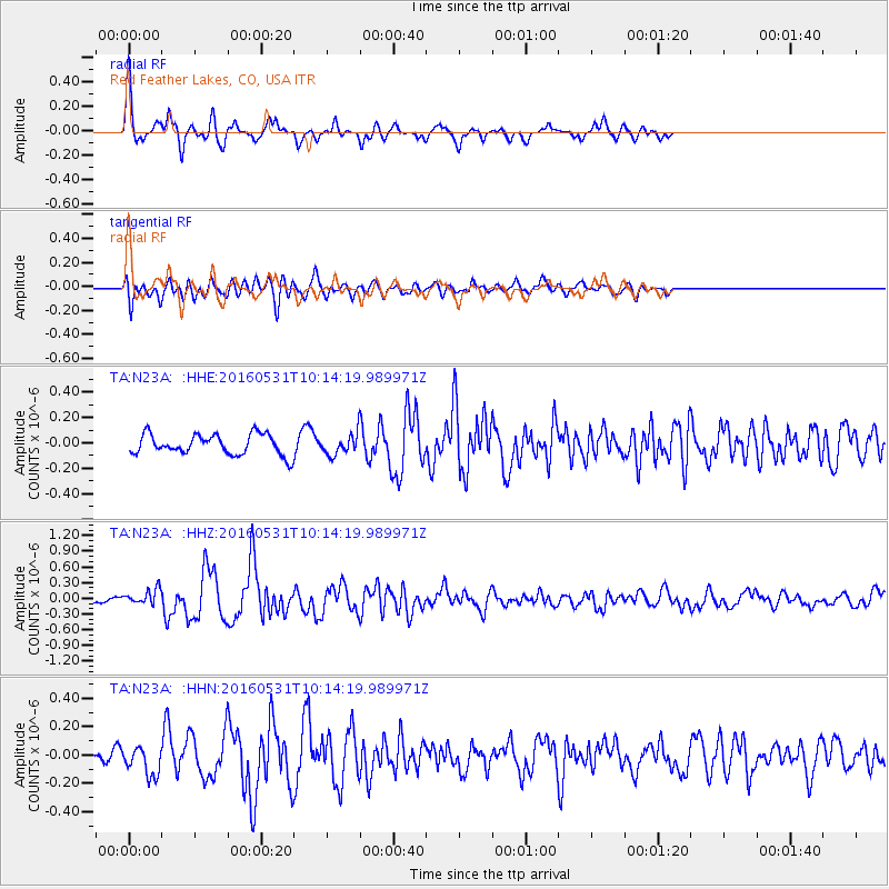
Signal To Noise
| Channel | StoN | STA | LTA |
| TA:N23A: :HHZ:20160531T10:14:19.989971Z | 2.0852237 | 1.4704095E-7 | 7.0515675E-8 |
| TA:N23A: :HHN:20160531T10:14:19.989971Z | 1.4598703 | 1.0116277E-7 | 6.929572E-8 |
| TA:N23A: :HHE:20160531T10:14:19.989971Z | 1.2935444 | 1.0381484E-7 | 8.025611E-8 |
| Arrivals |
| Ps | 6.3 SECOND |
| PpPs | 22 SECOND |
| PsPs/PpSs | 29 SECOND |


