You are here: Home > Network List > TA - USArray Transportable Network (new EarthScope stations) Stations List
> Station TPFO Pinon Flats, CA, USA > Earthquake Result Viewer
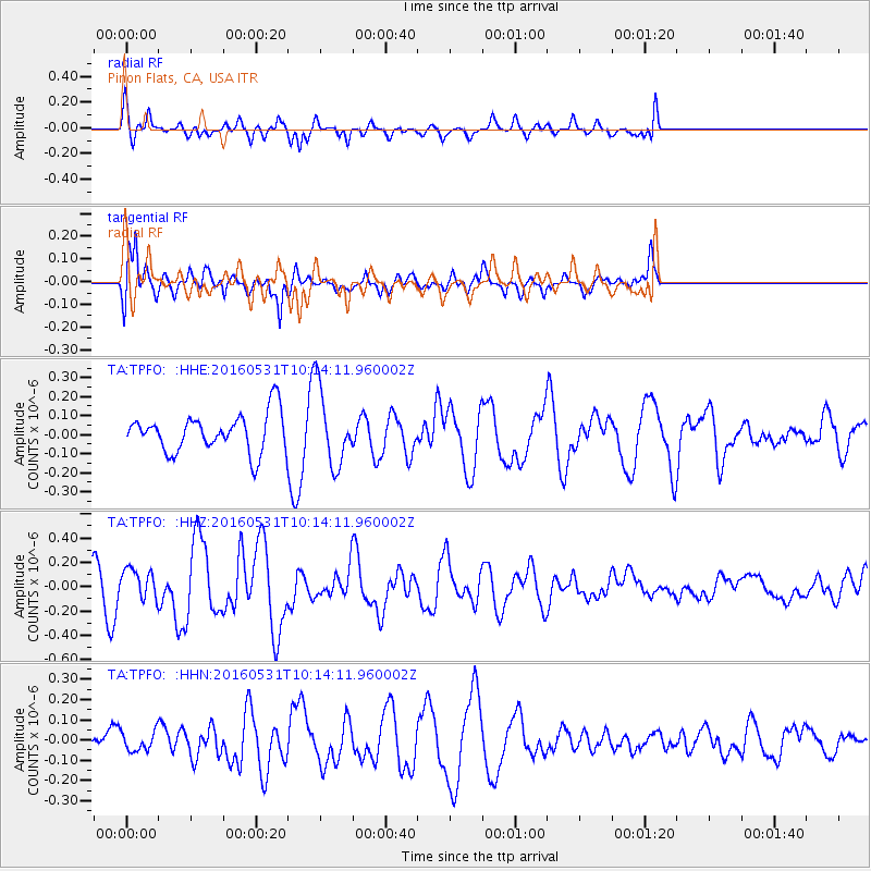
TPFO Pinon Flats, CA, USA - Earthquake Result Viewer
*The percent match for this event was below the threshold and hence no stack was calculated.
| Earthquake location: |
Kuril Islands |
| Earthquake latitude/longitude: |
47.5/154.4 |
| Earthquake time(UTC): |
2016/05/31 (152) 10:03:59 GMT |
| Earthquake Depth: |
10 km |
| Earthquake Magnitude: |
5.5 MB |
| Earthquake Catalog/Contributor: |
NEIC PDE/NEIC COMCAT |
|
| Network: |
TA USArray Transportable Network (new EarthScope stations) |
| Station: |
TPFO Pinon Flats, CA, USA |
| Lat/Lon: |
33.61 N/116.45 W |
| Elevation: |
1275 m |
|
| Distance: |
65.6 deg |
| Az: |
66.409 deg |
| Baz: |
311.939 deg |
| Ray Param: |
$rayparam |
*The percent match for this event was below the threshold and hence was not used in the summary stack. |
|
| Radial Match: |
42.542973 % |
| Radial Bump: |
341 |
| Transverse Match: |
53.170574 % |
| Transverse Bump: |
352 |
| SOD ConfigId: |
7422571 |
| Insert Time: |
2019-04-22 17:07:36.507 +0000 |
| GWidth: |
2.5 |
| Max Bumps: |
400 |
| Tol: |
0.001 |
|
Signal To Noise
| Channel | StoN | STA | LTA |
| TA:TPFO: :HHZ:20160531T10:14:11.960002Z | 0.8223478 | 1.2861705E-7 | 1.5640225E-7 |
| TA:TPFO: :HHN:20160531T10:14:11.960002Z | 0.33445472 | 4.767874E-8 | 1.4255664E-7 |
| TA:TPFO: :HHE:20160531T10:14:11.960002Z | 1.7367927 | 1.8041604E-7 | 1.03878854E-7 |
| Arrivals |
| Ps | |
| PpPs | |
| PsPs/PpSs | |


