You are here: Home > Network List > TA - USArray Transportable Network (new EarthScope stations) Stations List
> Station U40A Yellville, AR, USA > Earthquake Result Viewer
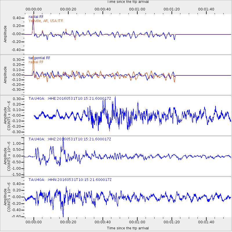
U40A Yellville, AR, USA - Earthquake Result Viewer
*The percent match for this event was below the threshold and hence no stack was calculated.
| Earthquake location: |
Kuril Islands |
| Earthquake latitude/longitude: |
47.5/154.4 |
| Earthquake time(UTC): |
2016/05/31 (152) 10:03:59 GMT |
| Earthquake Depth: |
10 km |
| Earthquake Magnitude: |
5.5 MB |
| Earthquake Catalog/Contributor: |
NEIC PDE/NEIC COMCAT |
|
| Network: |
TA USArray Transportable Network (new EarthScope stations) |
| Station: |
U40A Yellville, AR, USA |
| Lat/Lon: |
36.36 N/92.85 W |
| Elevation: |
374 m |
|
| Distance: |
77.1 deg |
| Az: |
49.763 deg |
| Baz: |
320.163 deg |
| Ray Param: |
$rayparam |
*The percent match for this event was below the threshold and hence was not used in the summary stack. |
|
| Radial Match: |
77.00153 % |
| Radial Bump: |
400 |
| Transverse Match: |
65.515465 % |
| Transverse Bump: |
400 |
| SOD ConfigId: |
7422571 |
| Insert Time: |
2019-04-22 17:07:37.684 +0000 |
| GWidth: |
2.5 |
| Max Bumps: |
400 |
| Tol: |
0.001 |
|
Signal To Noise
| Channel | StoN | STA | LTA |
| TA:U40A: :HHZ:20160531T10:15:21.600017Z | 6.6678348 | 3.188102E-7 | 4.7813153E-8 |
| TA:U40A: :HHN:20160531T10:15:21.600017Z | 2.2408252 | 1.07583226E-7 | 4.8010538E-8 |
| TA:U40A: :HHE:20160531T10:15:21.600017Z | 2.2652607 | 8.756759E-8 | 3.865674E-8 |
| Arrivals |
| Ps | |
| PpPs | |
| PsPs/PpSs | |


