You are here: Home > Network List > TJ - Tajikistan National Seismic Network Stations List
> Station GARM Garm, Tajikistan > Earthquake Result Viewer
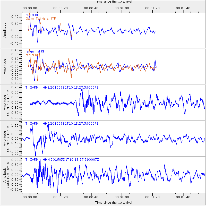
GARM Garm, Tajikistan - Earthquake Result Viewer
*The percent match for this event was below the threshold and hence no stack was calculated.
| Earthquake location: |
Kuril Islands |
| Earthquake latitude/longitude: |
47.5/154.4 |
| Earthquake time(UTC): |
2016/05/31 (152) 10:03:59 GMT |
| Earthquake Depth: |
10 km |
| Earthquake Magnitude: |
5.5 MB |
| Earthquake Catalog/Contributor: |
NEIC PDE/NEIC COMCAT |
|
| Network: |
TJ Tajikistan National Seismic Network |
| Station: |
GARM Garm, Tajikistan |
| Lat/Lon: |
39.00 N/70.32 E |
| Elevation: |
1305 m |
|
| Distance: |
59.0 deg |
| Az: |
295.228 deg |
| Baz: |
51.855 deg |
| Ray Param: |
$rayparam |
*The percent match for this event was below the threshold and hence was not used in the summary stack. |
|
| Radial Match: |
79.99003 % |
| Radial Bump: |
400 |
| Transverse Match: |
73.6921 % |
| Transverse Bump: |
400 |
| SOD ConfigId: |
7422571 |
| Insert Time: |
2019-04-22 17:07:50.894 +0000 |
| GWidth: |
2.5 |
| Max Bumps: |
400 |
| Tol: |
0.001 |
|
Signal To Noise
| Channel | StoN | STA | LTA |
| TJ:GARM: :HHZ:20160531T10:13:27.590007Z | 11.306399 | 9.703392E-7 | 8.582212E-8 |
| TJ:GARM: :HHN:20160531T10:13:27.590007Z | 4.0028186 | 2.947538E-7 | 7.3636556E-8 |
| TJ:GARM: :HHE:20160531T10:13:27.590007Z | 7.3830442 | 4.7064606E-7 | 6.374688E-8 |
| Arrivals |
| Ps | |
| PpPs | |
| PsPs/PpSs | |


