You are here: Home > Network List > KN - Kyrgyz Seismic Telemetry Network Stations List
> Station ULHL - > Earthquake Result Viewer
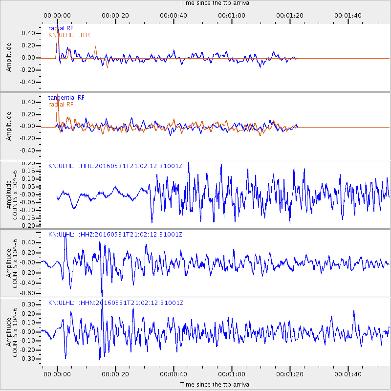
ULHL - - Earthquake Result Viewer
*The percent match for this event was below the threshold and hence no stack was calculated.
| Earthquake location: |
Alaska Peninsula |
| Earthquake latitude/longitude: |
55.4/-158.5 |
| Earthquake time(UTC): |
2016/05/31 (152) 20:51:22 GMT |
| Earthquake Depth: |
39 km |
| Earthquake Magnitude: |
5.7 MWW, 5.4 MI, 5.7 MWC, 5.8 MB, 5.8 MWB |
| Earthquake Catalog/Contributor: |
NEIC PDE/NEIC COMCAT |
|
| Network: |
KN Kyrgyz Seismic Telemetry Network |
| Station: |
ULHL - |
| Lat/Lon: |
42.25 N/76.24 E |
| Elevation: |
2040 m |
|
| Distance: |
72.2 deg |
| Az: |
320.423 deg |
| Baz: |
29.274 deg |
| Ray Param: |
$rayparam |
*The percent match for this event was below the threshold and hence was not used in the summary stack. |
|
| Radial Match: |
76.322136 % |
| Radial Bump: |
400 |
| Transverse Match: |
69.41691 % |
| Transverse Bump: |
400 |
| SOD ConfigId: |
7422571 |
| Insert Time: |
2019-04-22 17:15:12.387 +0000 |
| GWidth: |
2.5 |
| Max Bumps: |
400 |
| Tol: |
0.001 |
|
Signal To Noise
| Channel | StoN | STA | LTA |
| KN:ULHL: :HHZ:20160531T21:02:12.31001Z | 6.7778854 | 2.5120826E-7 | 3.7062925E-8 |
| KN:ULHL: :HHN:20160531T21:02:12.31001Z | 3.671487 | 1.17966366E-7 | 3.2130405E-8 |
| KN:ULHL: :HHE:20160531T21:02:12.31001Z | 2.6066236 | 7.0404454E-8 | 2.7009825E-8 |
| Arrivals |
| Ps | |
| PpPs | |
| PsPs/PpSs | |


