You are here: Home > Network List > LD - Lamont-Doherty Cooperative Seismographic Network Stations List
> Station TUPA Temple University, Pennsylvania > Earthquake Result Viewer
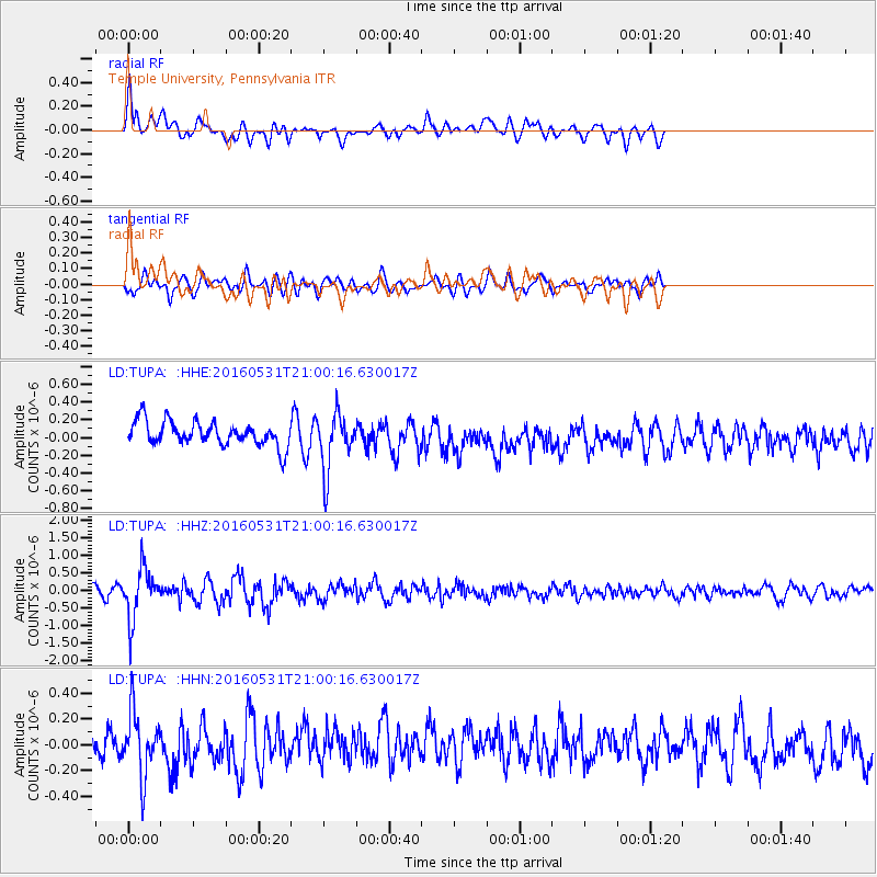
TUPA Temple University, Pennsylvania - Earthquake Result Viewer
*The percent match for this event was below the threshold and hence no stack was calculated.
| Earthquake location: |
Alaska Peninsula |
| Earthquake latitude/longitude: |
55.4/-158.5 |
| Earthquake time(UTC): |
2016/05/31 (152) 20:51:22 GMT |
| Earthquake Depth: |
39 km |
| Earthquake Magnitude: |
5.7 MWW, 5.4 MI, 5.7 MWC, 5.8 MB, 5.8 MWB |
| Earthquake Catalog/Contributor: |
NEIC PDE/NEIC COMCAT |
|
| Network: |
LD Lamont-Doherty Cooperative Seismographic Network |
| Station: |
TUPA Temple University, Pennsylvania |
| Lat/Lon: |
40.17 N/75.19 W |
| Elevation: |
112 m |
|
| Distance: |
54.6 deg |
| Az: |
68.94 deg |
| Baz: |
316.053 deg |
| Ray Param: |
$rayparam |
*The percent match for this event was below the threshold and hence was not used in the summary stack. |
|
| Radial Match: |
50.388184 % |
| Radial Bump: |
400 |
| Transverse Match: |
53.168243 % |
| Transverse Bump: |
400 |
| SOD ConfigId: |
7422571 |
| Insert Time: |
2019-04-22 17:16:02.148 +0000 |
| GWidth: |
2.5 |
| Max Bumps: |
400 |
| Tol: |
0.001 |
|
Signal To Noise
| Channel | StoN | STA | LTA |
| LD:TUPA: :HHZ:20160531T21:00:16.630017Z | 5.1913447 | 7.108777E-7 | 1.3693517E-7 |
| LD:TUPA: :HHN:20160531T21:00:16.630017Z | 1.860393 | 2.3832969E-7 | 1.2810717E-7 |
| LD:TUPA: :HHE:20160531T21:00:16.630017Z | 2.3548918 | 3.233359E-7 | 1.3730394E-7 |
| Arrivals |
| Ps | |
| PpPs | |
| PsPs/PpSs | |


