You are here: Home > Network List > II - Global Seismograph Network (GSN - IRIS/IDA) Stations List
> Station WRAB Tennant Creek, NT, Australia > Earthquake Result Viewer
WRAB Tennant Creek, NT, Australia - Earthquake Result Viewer
*The percent match for this event was below the threshold and hence no stack was calculated.
| Earthquake location: |
Southeast Of Honshu, Japan |
| Earthquake latitude/longitude: |
31.3/141.9 |
| Earthquake time(UTC): |
2015/09/01 (244) 15:24:10 GMT |
| Earthquake Depth: |
22 km |
| Earthquake Magnitude: |
5.6 MB |
| Earthquake Catalog/Contributor: |
NEIC PDE/NEIC ALERT |
|
| Network: |
II Global Seismograph Network (GSN - IRIS/IDA) |
| Station: |
WRAB Tennant Creek, NT, Australia |
| Lat/Lon: |
19.93 S/134.36 E |
| Elevation: |
366 m |
|
| Distance: |
51.5 deg |
| Az: |
189.037 deg |
| Baz: |
8.212 deg |
| Ray Param: |
$rayparam |
*The percent match for this event was below the threshold and hence was not used in the summary stack. |
|
| Radial Match: |
72.05023 % |
| Radial Bump: |
348 |
| Transverse Match: |
50.057995 % |
| Transverse Bump: |
400 |
| SOD ConfigId: |
1085051 |
| Insert Time: |
2015-09-15 15:36:24.942 +0000 |
| GWidth: |
2.5 |
| Max Bumps: |
400 |
| Tol: |
0.001 |
|
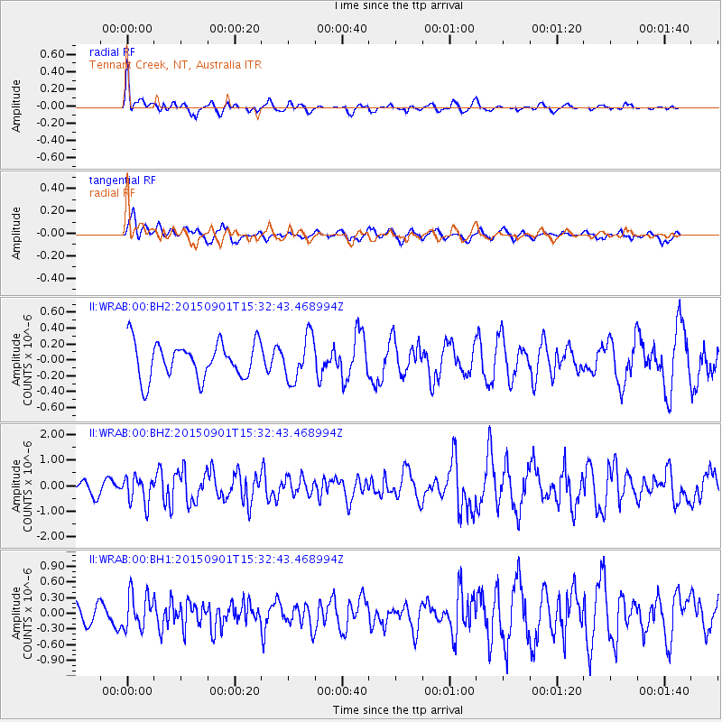
Signal To Noise
| Channel | StoN | STA | LTA |
| II:WRAB:00:BHZ:20150901T15:32:43.468994Z | 2.984907 | 5.228769E-7 | 1.7517361E-7 |
| II:WRAB:00:BH1:20150901T15:32:43.468994Z | 1.8062559 | 3.3779492E-7 | 1.8701387E-7 |
| II:WRAB:00:BH2:20150901T15:32:43.468994Z | 1.2263662 | 2.776368E-7 | 2.2638982E-7 |
| Arrivals |
| Ps | |
| PpPs | |
| PsPs/PpSs | |


