You are here: Home > Network List > IU - Global Seismograph Network (GSN - IRIS/USGS) Stations List
> Station MAKZ Makanchi, Kazakhstan > Earthquake Result Viewer
MAKZ Makanchi, Kazakhstan - Earthquake Result Viewer
| Earthquake location: |
Southeast Of Honshu, Japan |
| Earthquake latitude/longitude: |
31.3/141.9 |
| Earthquake time(UTC): |
2015/09/01 (244) 15:24:10 GMT |
| Earthquake Depth: |
22 km |
| Earthquake Magnitude: |
5.6 MB |
| Earthquake Catalog/Contributor: |
NEIC PDE/NEIC ALERT |
|
| Network: |
IU Global Seismograph Network (GSN - IRIS/USGS) |
| Station: |
MAKZ Makanchi, Kazakhstan |
| Lat/Lon: |
46.81 N/81.98 E |
| Elevation: |
600 m |
|
| Distance: |
47.9 deg |
| Az: |
306.732 deg |
| Baz: |
86.624 deg |
| Ray Param: |
0.06969898 |
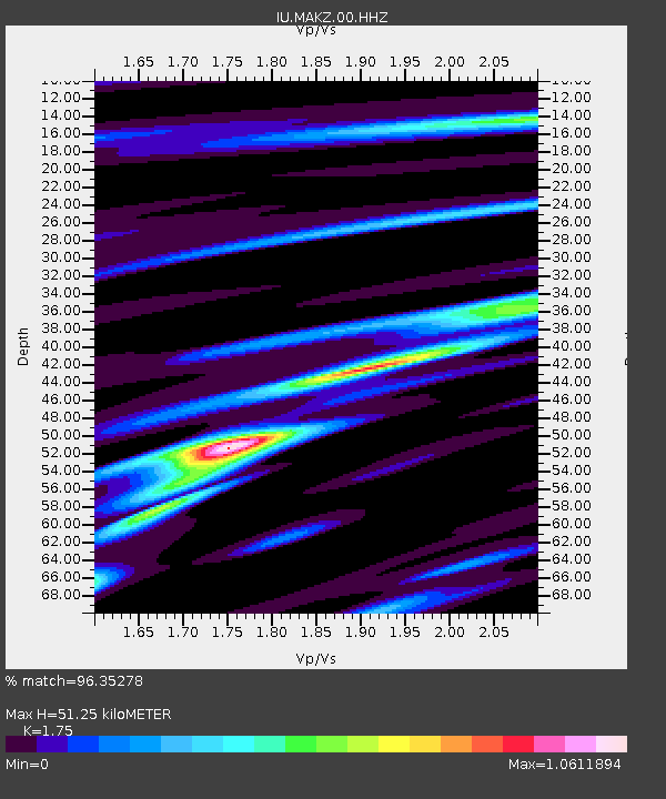
| Estimated Moho Depth: |
51.25 km |
| Estimated Crust Vp/Vs: |
1.75 |
| Assumed Crust Vp: |
6.571 km/s |
| Estimated Crust Vs: |
3.755 km/s |
| Estimated Crust Poisson's Ratio: |
0.26 |
|
| Radial Match: |
96.35278 % |
| Radial Bump: |
278 |
| Transverse Match: |
91.1043 % |
| Transverse Bump: |
400 |
| SOD ConfigId: |
1085051 |
| Insert Time: |
2015-09-15 15:36:42.882 +0000 |
| GWidth: |
2.5 |
| Max Bumps: |
400 |
| Tol: |
0.001 |
|

Signal To Noise
| Channel | StoN | STA | LTA |
| IU:MAKZ:00:HHZ:20150901T15:32:15.778015Z | 6.933206 | 5.1794507E-7 | 7.4704985E-8 |
| IU:MAKZ:00:HH1:20150901T15:32:15.778015Z | 3.041541 | 5.954652E-8 | 1.9577746E-8 |
| IU:MAKZ:00:HH2:20150901T15:32:15.778015Z | 8.072633 | 2.6816042E-7 | 3.321846E-8 |
| Arrivals |
| Ps | 6.2 SECOND |
| PpPs | 20 SECOND |
| PsPs/PpSs | 26 SECOND |


