You are here: Home > Network List > N4 - Central and EAstern US Network Stations List
> Station N47A Urbana, IN, USA > Earthquake Result Viewer
N47A Urbana, IN, USA - Earthquake Result Viewer
| Earthquake location: |
Alaska Peninsula |
| Earthquake latitude/longitude: |
55.4/-158.5 |
| Earthquake time(UTC): |
2016/05/31 (152) 20:51:22 GMT |
| Earthquake Depth: |
39 km |
| Earthquake Magnitude: |
5.7 MWW, 5.4 MI, 5.7 MWC, 5.8 MB, 5.8 MWB |
| Earthquake Catalog/Contributor: |
NEIC PDE/NEIC COMCAT |
|
| Network: |
N4 Central and EAstern US Network |
| Station: |
N47A Urbana, IN, USA |
| Lat/Lon: |
40.88 N/85.69 W |
| Elevation: |
252 m |
|
| Distance: |
48.4 deg |
| Az: |
75.482 deg |
| Baz: |
313.317 deg |
| Ray Param: |
0.06926584 |
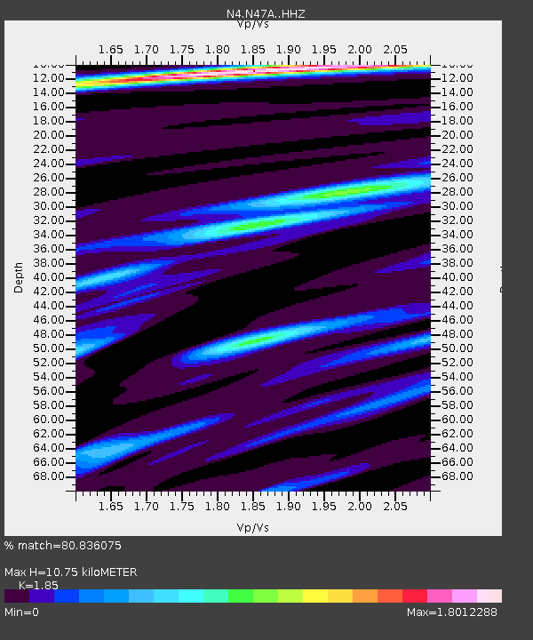
| Estimated Moho Depth: |
10.75 km |
| Estimated Crust Vp/Vs: |
1.85 |
| Assumed Crust Vp: |
6.498 km/s |
| Estimated Crust Vs: |
3.512 km/s |
| Estimated Crust Poisson's Ratio: |
0.29 |
|
| Radial Match: |
80.836075 % |
| Radial Bump: |
323 |
| Transverse Match: |
38.140038 % |
| Transverse Bump: |
400 |
| SOD ConfigId: |
7422571 |
| Insert Time: |
2019-04-22 17:17:34.046 +0000 |
| GWidth: |
2.5 |
| Max Bumps: |
400 |
| Tol: |
0.001 |
|

Signal To Noise
| Channel | StoN | STA | LTA |
| N4:N47A: :HHZ:20160531T20:59:30.359998Z | 9.771642 | 1.0407772E-6 | 1.06509965E-7 |
| N4:N47A: :HHN:20160531T20:59:30.359998Z | 3.63156 | 3.6947714E-7 | 1.0174061E-7 |
| N4:N47A: :HHE:20160531T20:59:30.359998Z | 4.6246595 | 4.0586986E-7 | 8.7762096E-8 |
| Arrivals |
| Ps | 1.5 SECOND |
| PpPs | 4.4 SECOND |
| PsPs/PpSs | 5.9 SECOND |


