You are here: Home > Network List > US - United States National Seismic Network Stations List
> Station MNTX Cornudas Mountains, Texas, USA > Earthquake Result Viewer
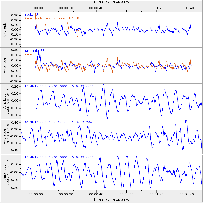
MNTX Cornudas Mountains, Texas, USA - Earthquake Result Viewer
*The percent match for this event was below the threshold and hence no stack was calculated.
| Earthquake location: |
Southeast Of Honshu, Japan |
| Earthquake latitude/longitude: |
31.3/141.9 |
| Earthquake time(UTC): |
2015/09/01 (244) 15:24:10 GMT |
| Earthquake Depth: |
22 km |
| Earthquake Magnitude: |
5.6 MB |
| Earthquake Catalog/Contributor: |
NEIC PDE/NEIC ALERT |
|
| Network: |
US United States National Seismic Network |
| Station: |
MNTX Cornudas Mountains, Texas, USA |
| Lat/Lon: |
31.70 N/105.38 W |
| Elevation: |
404 m |
|
| Distance: |
90.6 deg |
| Az: |
51.825 deg |
| Baz: |
307.903 deg |
| Ray Param: |
$rayparam |
*The percent match for this event was below the threshold and hence was not used in the summary stack. |
|
| Radial Match: |
57.758324 % |
| Radial Bump: |
375 |
| Transverse Match: |
62.041306 % |
| Transverse Bump: |
324 |
| SOD ConfigId: |
1085051 |
| Insert Time: |
2015-09-15 15:39:49.547 +0000 |
| GWidth: |
2.5 |
| Max Bumps: |
400 |
| Tol: |
0.001 |
|
Signal To Noise
| Channel | StoN | STA | LTA |
| US:MNTX:00:BHZ:20150901T15:36:39.750Z | 1.7817806 | 2.1366651E-7 | 1.199174E-7 |
| US:MNTX:00:BH1:20150901T15:36:39.750Z | 1.3333606 | 7.6529716E-8 | 5.7396115E-8 |
| US:MNTX:00:BH2:20150901T15:36:39.750Z | 1.9167598 | 1.365463E-7 | 7.123809E-8 |
| Arrivals |
| Ps | |
| PpPs | |
| PsPs/PpSs | |


