You are here: Home > Network List > TA - USArray Transportable Network (new EarthScope stations) Stations List
> Station S22A 4UR Ranch, Creede, CO, USA > Earthquake Result Viewer
S22A 4UR Ranch, Creede, CO, USA - Earthquake Result Viewer
| Earthquake location: |
Alaska Peninsula |
| Earthquake latitude/longitude: |
55.4/-158.5 |
| Earthquake time(UTC): |
2016/05/31 (152) 20:51:22 GMT |
| Earthquake Depth: |
39 km |
| Earthquake Magnitude: |
5.7 MWW, 5.4 MI, 5.7 MWC, 5.8 MB, 5.8 MWB |
| Earthquake Catalog/Contributor: |
NEIC PDE/NEIC COMCAT |
|
| Network: |
TA USArray Transportable Network (new EarthScope stations) |
| Station: |
S22A 4UR Ranch, Creede, CO, USA |
| Lat/Lon: |
37.75 N/106.83 W |
| Elevation: |
2626 m |
|
| Distance: |
38.7 deg |
| Az: |
95.178 deg |
| Baz: |
314.278 deg |
| Ray Param: |
0.075350754 |
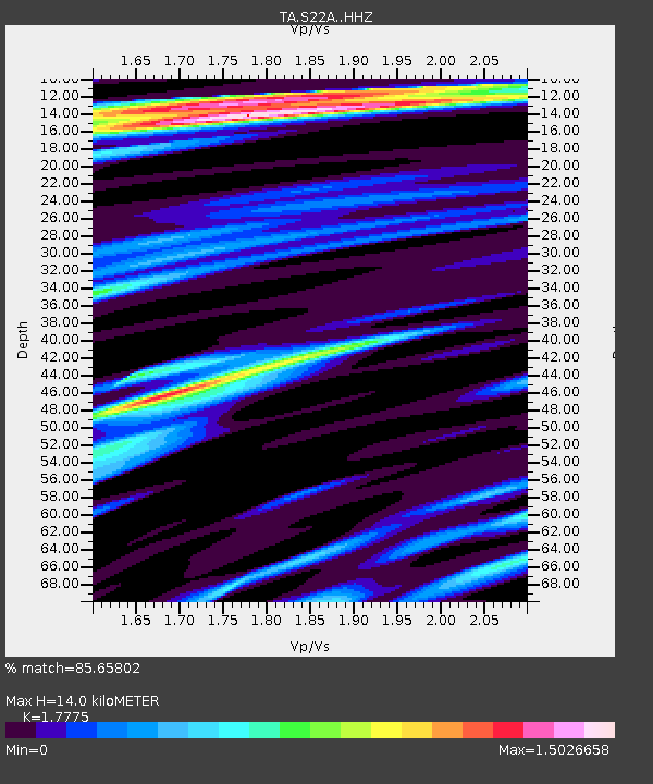
| Estimated Moho Depth: |
14.0 km |
| Estimated Crust Vp/Vs: |
1.78 |
| Assumed Crust Vp: |
6.159 km/s |
| Estimated Crust Vs: |
3.465 km/s |
| Estimated Crust Poisson's Ratio: |
0.27 |
|
| Radial Match: |
85.65802 % |
| Radial Bump: |
400 |
| Transverse Match: |
50.334507 % |
| Transverse Bump: |
400 |
| SOD ConfigId: |
7422571 |
| Insert Time: |
2019-04-22 17:22:29.804 +0000 |
| GWidth: |
2.5 |
| Max Bumps: |
400 |
| Tol: |
0.001 |
|
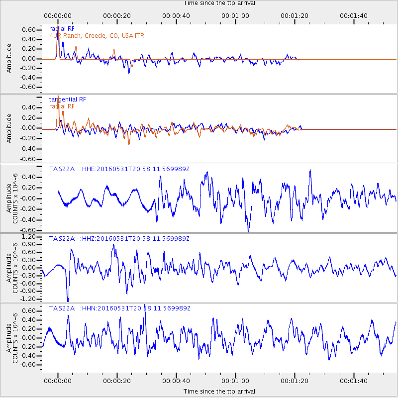
Signal To Noise
| Channel | StoN | STA | LTA |
| TA:S22A: :HHZ:20160531T20:58:11.569989Z | 2.2991695 | 5.092111E-7 | 2.2147609E-7 |
| TA:S22A: :HHN:20160531T20:58:11.569989Z | 1.254739 | 1.9922827E-7 | 1.5878065E-7 |
| TA:S22A: :HHE:20160531T20:58:11.569989Z | 2.4101043 | 2.3275305E-7 | 9.657385E-8 |
| Arrivals |
| Ps | 1.9 SECOND |
| PpPs | 5.9 SECOND |
| PsPs/PpSs | 7.8 SECOND |


