You are here: Home > Network List > TA - USArray Transportable Network (new EarthScope stations) Stations List
> Station TUL1 Leonard, OK, USA > Earthquake Result Viewer
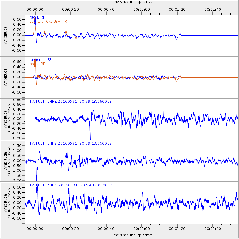
TUL1 Leonard, OK, USA - Earthquake Result Viewer
*The percent match for this event was below the threshold and hence no stack was calculated.
| Earthquake location: |
Alaska Peninsula |
| Earthquake latitude/longitude: |
55.4/-158.5 |
| Earthquake time(UTC): |
2016/05/31 (152) 20:51:22 GMT |
| Earthquake Depth: |
39 km |
| Earthquake Magnitude: |
5.7 MWW, 5.4 MI, 5.7 MWC, 5.8 MB, 5.8 MWB |
| Earthquake Catalog/Contributor: |
NEIC PDE/NEIC COMCAT |
|
| Network: |
TA USArray Transportable Network (new EarthScope stations) |
| Station: |
TUL1 Leonard, OK, USA |
| Lat/Lon: |
35.91 N/95.79 W |
| Elevation: |
256 m |
|
| Distance: |
46.2 deg |
| Az: |
87.845 deg |
| Baz: |
315.453 deg |
| Ray Param: |
$rayparam |
*The percent match for this event was below the threshold and hence was not used in the summary stack. |
|
| Radial Match: |
77.933014 % |
| Radial Bump: |
400 |
| Transverse Match: |
60.950245 % |
| Transverse Bump: |
400 |
| SOD ConfigId: |
7422571 |
| Insert Time: |
2019-04-22 17:22:34.739 +0000 |
| GWidth: |
2.5 |
| Max Bumps: |
400 |
| Tol: |
0.001 |
|
Signal To Noise
| Channel | StoN | STA | LTA |
| TA:TUL1: :HHZ:20160531T20:59:13.06001Z | 7.7916055 | 6.1928046E-7 | 7.9480465E-8 |
| TA:TUL1: :HHN:20160531T20:59:13.06001Z | 3.4028893 | 3.09612E-7 | 9.098504E-8 |
| TA:TUL1: :HHE:20160531T20:59:13.06001Z | 4.6419153 | 2.9507027E-7 | 6.3566496E-8 |
| Arrivals |
| Ps | |
| PpPs | |
| PsPs/PpSs | |


