You are here: Home > Network List > XL12 - Hangay Dome, Mongolia Stations List
> Station AT06 AT06 > Earthquake Result Viewer
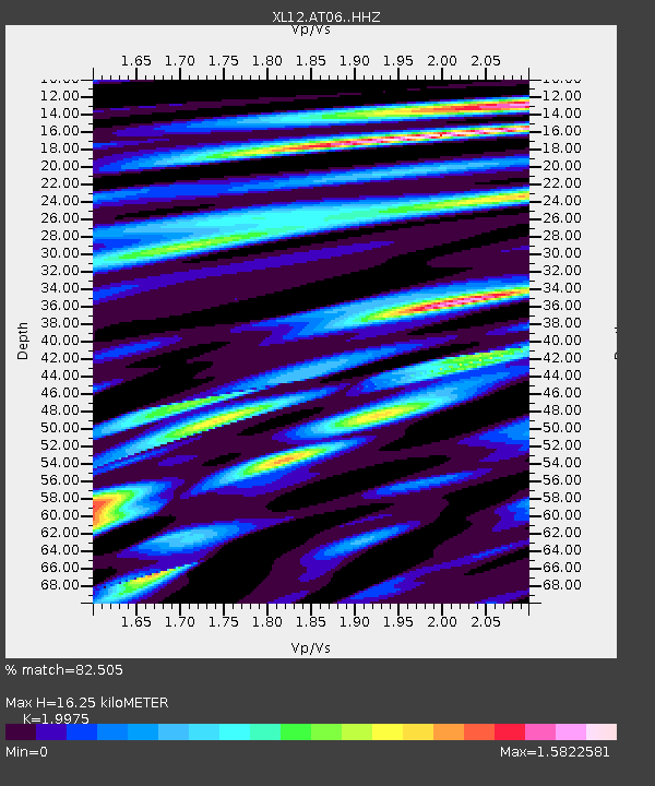
AT06 AT06 - Earthquake Result Viewer
| Earthquake location: |
Alaska Peninsula |
| Earthquake latitude/longitude: |
55.4/-158.5 |
| Earthquake time(UTC): |
2016/05/31 (152) 20:51:22 GMT |
| Earthquake Depth: |
39 km |
| Earthquake Magnitude: |
5.7 MWW, 5.4 MI, 5.7 MWC, 5.8 MB, 5.8 MWB |
| Earthquake Catalog/Contributor: |
NEIC PDE/NEIC COMCAT |
|
| Network: |
XL Hangay Dome, Mongolia |
| Station: |
AT06 AT06 |
| Lat/Lon: |
46.35 N/96.51 E |
| Elevation: |
2047 m |
|
| Distance: |
60.6 deg |
| Az: |
309.823 deg |
| Baz: |
39.188 deg |
| Ray Param: |
0.061342284 |
| Estimated Moho Depth: |
16.25 km |
| Estimated Crust Vp/Vs: |
2.00 |
| Assumed Crust Vp: |
6.642 km/s |
| Estimated Crust Vs: |
3.325 km/s |
| Estimated Crust Poisson's Ratio: |
0.33 |
|
| Radial Match: |
82.505 % |
| Radial Bump: |
400 |
| Transverse Match: |
73.26559 % |
| Transverse Bump: |
400 |
| SOD ConfigId: |
7422571 |
| Insert Time: |
2019-04-22 17:24:06.742 +0000 |
| GWidth: |
2.5 |
| Max Bumps: |
400 |
| Tol: |
0.001 |
|

Signal To Noise
| Channel | StoN | STA | LTA |
| XL:AT06: :HHZ:20160531T21:00:58.599988Z | 12.497767 | 3.0749842E-7 | 2.4604269E-8 |
| XL:AT06: :HHN:20160531T21:00:58.599988Z | 6.520432 | 1.5171044E-7 | 2.3266931E-8 |
| XL:AT06: :HHE:20160531T21:00:58.599988Z | 4.877985 | 9.9633354E-8 | 2.0425105E-8 |
| Arrivals |
| Ps | 2.6 SECOND |
| PpPs | 7.0 SECOND |
| PsPs/PpSs | 9.6 SECOND |


