You are here: Home > Network List > XL12 - Hangay Dome, Mongolia Stations List
> Station AT12 AT12 > Earthquake Result Viewer
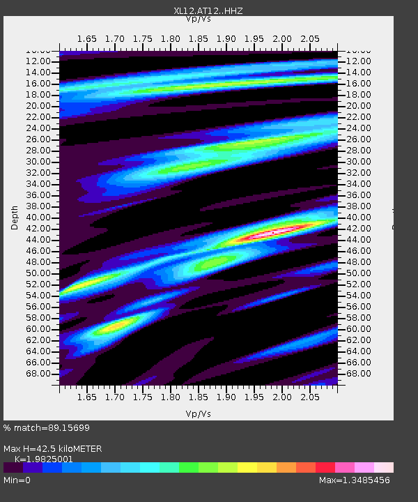
AT12 AT12 - Earthquake Result Viewer
| Earthquake location: |
Alaska Peninsula |
| Earthquake latitude/longitude: |
55.4/-158.5 |
| Earthquake time(UTC): |
2016/05/31 (152) 20:51:22 GMT |
| Earthquake Depth: |
39 km |
| Earthquake Magnitude: |
5.7 MWW, 5.4 MI, 5.7 MWC, 5.8 MB, 5.8 MWB |
| Earthquake Catalog/Contributor: |
NEIC PDE/NEIC COMCAT |
|
| Network: |
XL Hangay Dome, Mongolia |
| Station: |
AT12 AT12 |
| Lat/Lon: |
44.66 N/96.01 E |
| Elevation: |
1596 m |
|
| Distance: |
62.1 deg |
| Az: |
308.929 deg |
| Baz: |
38.407 deg |
| Ray Param: |
0.060346037 |
| Estimated Moho Depth: |
42.5 km |
| Estimated Crust Vp/Vs: |
1.98 |
| Assumed Crust Vp: |
6.353 km/s |
| Estimated Crust Vs: |
3.205 km/s |
| Estimated Crust Poisson's Ratio: |
0.33 |
|
| Radial Match: |
89.15699 % |
| Radial Bump: |
394 |
| Transverse Match: |
75.66502 % |
| Transverse Bump: |
400 |
| SOD ConfigId: |
7422571 |
| Insert Time: |
2019-04-22 17:24:11.114 +0000 |
| GWidth: |
2.5 |
| Max Bumps: |
400 |
| Tol: |
0.001 |
|

Signal To Noise
| Channel | StoN | STA | LTA |
| XL:AT12: :HHZ:20160531T21:01:08.940015Z | 13.128383 | 3.462899E-7 | 2.6377194E-8 |
| XL:AT12: :HHN:20160531T21:01:08.940015Z | 5.5254254 | 9.257593E-8 | 1.6754536E-8 |
| XL:AT12: :HHE:20160531T21:01:08.940015Z | 4.414835 | 8.12735E-8 | 1.840918E-8 |
| Arrivals |
| Ps | 6.8 SECOND |
| PpPs | 19 SECOND |
| PsPs/PpSs | 26 SECOND |


