You are here: Home > Network List > XL12 - Hangay Dome, Mongolia Stations List
> Station HV03 HV03 > Earthquake Result Viewer
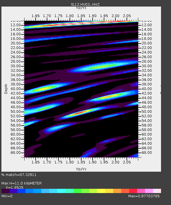
HV03 HV03 - Earthquake Result Viewer
| Earthquake location: |
Alaska Peninsula |
| Earthquake latitude/longitude: |
55.4/-158.5 |
| Earthquake time(UTC): |
2016/05/31 (152) 20:51:22 GMT |
| Earthquake Depth: |
39 km |
| Earthquake Magnitude: |
5.7 MWW, 5.4 MI, 5.7 MWC, 5.8 MB, 5.8 MWB |
| Earthquake Catalog/Contributor: |
NEIC PDE/NEIC COMCAT |
|
| Network: |
XL Hangay Dome, Mongolia |
| Station: |
HV03 HV03 |
| Lat/Lon: |
50.99 N/99.15 E |
| Elevation: |
1639 m |
|
| Distance: |
55.9 deg |
| Az: |
311.826 deg |
| Baz: |
42.22 deg |
| Ray Param: |
0.06438269 |
| Estimated Moho Depth: |
11.0 km |
| Estimated Crust Vp/Vs: |
1.85 |
| Assumed Crust Vp: |
6.622 km/s |
| Estimated Crust Vs: |
3.575 km/s |
| Estimated Crust Poisson's Ratio: |
0.29 |
|
| Radial Match: |
87.32911 % |
| Radial Bump: |
400 |
| Transverse Match: |
71.2639 % |
| Transverse Bump: |
400 |
| SOD ConfigId: |
7422571 |
| Insert Time: |
2019-04-22 17:24:16.306 +0000 |
| GWidth: |
2.5 |
| Max Bumps: |
400 |
| Tol: |
0.001 |
|

Signal To Noise
| Channel | StoN | STA | LTA |
| XL:HV03: :HHZ:20160531T21:00:26.120007Z | 12.346633 | 3.0939015E-7 | 2.5058666E-8 |
| XL:HV03: :HHN:20160531T21:00:26.120007Z | 3.4877 | 1.15095546E-7 | 3.3000415E-8 |
| XL:HV03: :HHE:20160531T21:00:26.120007Z | 7.368486 | 1.5469081E-7 | 2.0993568E-8 |
| Arrivals |
| Ps | 1.5 SECOND |
| PpPs | 4.5 SECOND |
| PsPs/PpSs | 6.0 SECOND |


