You are here: Home > Network List > XL12 - Hangay Dome, Mongolia Stations List
> Station HV05 HV05 > Earthquake Result Viewer
HV05 HV05 - Earthquake Result Viewer
| Earthquake location: |
Alaska Peninsula |
| Earthquake latitude/longitude: |
55.4/-158.5 |
| Earthquake time(UTC): |
2016/05/31 (152) 20:51:22 GMT |
| Earthquake Depth: |
39 km |
| Earthquake Magnitude: |
5.7 MWW, 5.4 MI, 5.7 MWC, 5.8 MB, 5.8 MWB |
| Earthquake Catalog/Contributor: |
NEIC PDE/NEIC COMCAT |
|
| Network: |
XL Hangay Dome, Mongolia |
| Station: |
HV05 HV05 |
| Lat/Lon: |
50.38 N/99.31 E |
| Elevation: |
1828 m |
|
| Distance: |
56.3 deg |
| Az: |
311.24 deg |
| Baz: |
42.019 deg |
| Ray Param: |
0.064133294 |
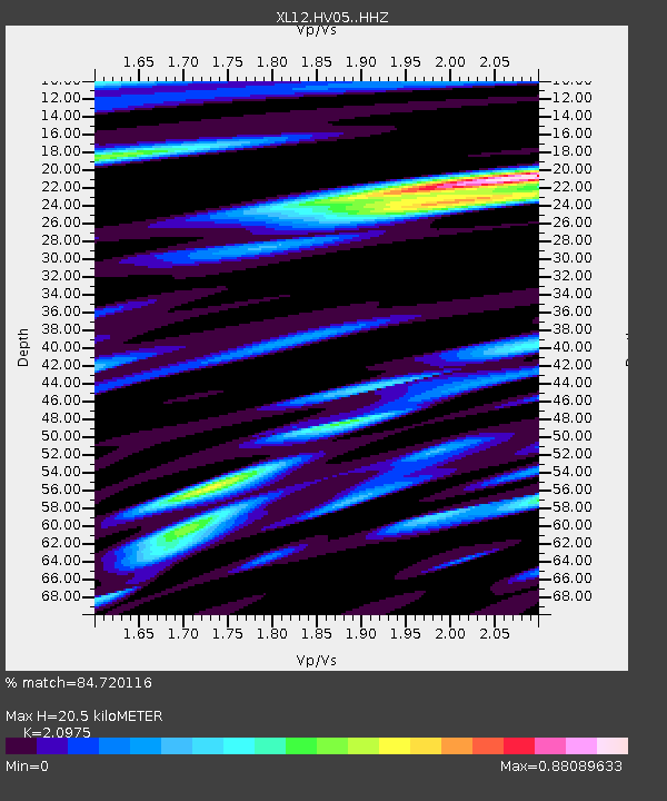
| Estimated Moho Depth: |
20.5 km |
| Estimated Crust Vp/Vs: |
2.10 |
| Assumed Crust Vp: |
6.622 km/s |
| Estimated Crust Vs: |
3.157 km/s |
| Estimated Crust Poisson's Ratio: |
0.35 |
|
| Radial Match: |
84.720116 % |
| Radial Bump: |
400 |
| Transverse Match: |
69.24729 % |
| Transverse Bump: |
400 |
| SOD ConfigId: |
7422571 |
| Insert Time: |
2019-04-22 17:24:18.680 +0000 |
| GWidth: |
2.5 |
| Max Bumps: |
400 |
| Tol: |
0.001 |
|

Signal To Noise
| Channel | StoN | STA | LTA |
| XL:HV05: :HHZ:20160531T21:00:28.849988Z | 11.395027 | 2.6744894E-7 | 2.3470673E-8 |
| XL:HV05: :HHN:20160531T21:00:28.849988Z | 5.610389 | 8.489989E-8 | 1.5132619E-8 |
| XL:HV05: :HHE:20160531T21:00:28.849988Z | 6.616773 | 7.946752E-8 | 1.2010012E-8 |
| Arrivals |
| Ps | 3.6 SECOND |
| PpPs | 9.2 SECOND |
| PsPs/PpSs | 13 SECOND |


