You are here: Home > Network List > XL12 - Hangay Dome, Mongolia Stations List
> Station HV10 HV10 > Earthquake Result Viewer
HV10 HV10 - Earthquake Result Viewer
| Earthquake location: |
Alaska Peninsula |
| Earthquake latitude/longitude: |
55.4/-158.5 |
| Earthquake time(UTC): |
2016/05/31 (152) 20:51:22 GMT |
| Earthquake Depth: |
39 km |
| Earthquake Magnitude: |
5.7 MWW, 5.4 MI, 5.7 MWC, 5.8 MB, 5.8 MWB |
| Earthquake Catalog/Contributor: |
NEIC PDE/NEIC COMCAT |
|
| Network: |
XL Hangay Dome, Mongolia |
| Station: |
HV10 HV10 |
| Lat/Lon: |
51.57 N/100.45 E |
| Elevation: |
1685 m |
|
| Distance: |
55.0 deg |
| Az: |
311.574 deg |
| Baz: |
43.087 deg |
| Ray Param: |
0.065022826 |
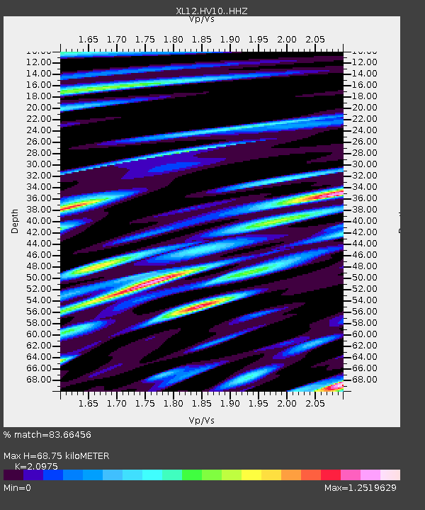
| Estimated Moho Depth: |
68.75 km |
| Estimated Crust Vp/Vs: |
2.10 |
| Assumed Crust Vp: |
6.419 km/s |
| Estimated Crust Vs: |
3.06 km/s |
| Estimated Crust Poisson's Ratio: |
0.35 |
|
| Radial Match: |
83.66456 % |
| Radial Bump: |
400 |
| Transverse Match: |
73.314064 % |
| Transverse Bump: |
400 |
| SOD ConfigId: |
7422571 |
| Insert Time: |
2019-04-22 17:24:22.323 +0000 |
| GWidth: |
2.5 |
| Max Bumps: |
400 |
| Tol: |
0.001 |
|

Signal To Noise
| Channel | StoN | STA | LTA |
| XL:HV10: :HHZ:20160531T21:00:19.099988Z | 10.252488 | 3.3128654E-7 | 3.2312794E-8 |
| XL:HV10: :HHN:20160531T21:00:19.099988Z | 3.4619696 | 9.2229506E-8 | 2.664076E-8 |
| XL:HV10: :HHE:20160531T21:00:19.099988Z | 8.846111 | 1.7916828E-7 | 2.0253903E-8 |
| Arrivals |
| Ps | 12 SECOND |
| PpPs | 32 SECOND |
| PsPs/PpSs | 44 SECOND |


