You are here: Home > Network List > US - United States National Seismic Network Stations List
> Station DUG Dugway, Tooele County, Utah, USA > Earthquake Result Viewer
DUG Dugway, Tooele County, Utah, USA - Earthquake Result Viewer

| Earthquake location: |
Chile-Argentina Border Region |
| Earthquake latitude/longitude: |
-33.9/-70.1 |
| Earthquake time(UTC): |
2000/06/16 (168) 07:55:35 GMT |
| Earthquake Depth: |
120 km |
| Earthquake Magnitude: |
6.2 MB, 6.5 MW, 6.1 MD |
| Earthquake Catalog/Contributor: |
WHDF/NEIC |
|
| Network: |
US United States National Seismic Network |
| Station: |
DUG Dugway, Tooele County, Utah, USA |
| Lat/Lon: |
40.19 N/112.81 W |
| Elevation: |
1477 m |
|
| Distance: |
83.6 deg |
| Az: |
328.468 deg |
| Baz: |
145.388 deg |
| Ray Param: |
0.04580256 |
| Estimated Moho Depth: |
29.5 km |
| Estimated Crust Vp/Vs: |
1.74 |
| Assumed Crust Vp: |
6.276 km/s |
| Estimated Crust Vs: |
3.612 km/s |
| Estimated Crust Poisson's Ratio: |
0.25 |
|
| Radial Match: |
93.50368 % |
| Radial Bump: |
400 |
| Transverse Match: |
89.23875 % |
| Transverse Bump: |
400 |
| SOD ConfigId: |
110165 |
| Insert Time: |
2010-03-05 04:06:54.550 +0000 |
| GWidth: |
2.5 |
| Max Bumps: |
400 |
| Tol: |
0.001 |
|
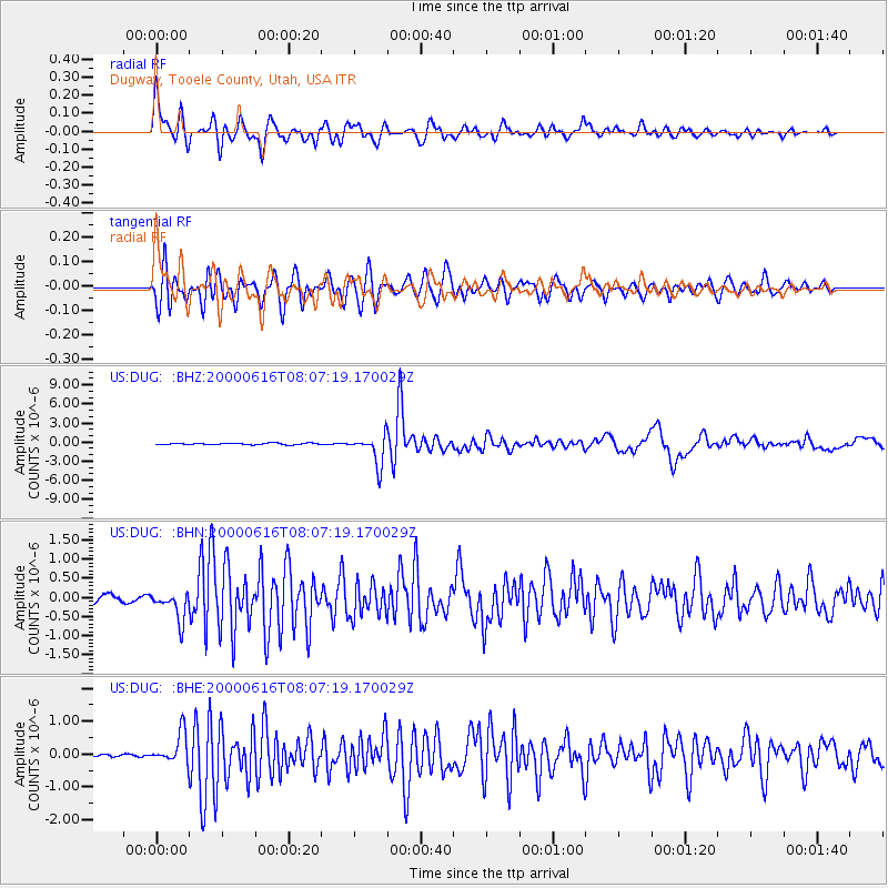
Signal To Noise
| Channel | StoN | STA | LTA |
| US:DUG: :BHN:20000616T08:07:19.170029Z | 2.9988217 | 3.7848497E-7 | 1.2621123E-7 |
| US:DUG: :BHE:20000616T08:07:19.170029Z | 8.653461 | 4.722759E-7 | 5.4576528E-8 |
| US:DUG: :BHZ:20000616T08:07:19.170029Z | 21.338518 | 2.3424727E-6 | 1.09776735E-7 |
| Arrivals |
| Ps | 3.6 SECOND |
| PpPs | 13 SECOND |
| PsPs/PpSs | 16 SECOND |


