You are here: Home > Network List > TA - USArray Transportable Network (new EarthScope stations) Stations List
> Station J26L Joseph Creek, AK, USA > Earthquake Result Viewer
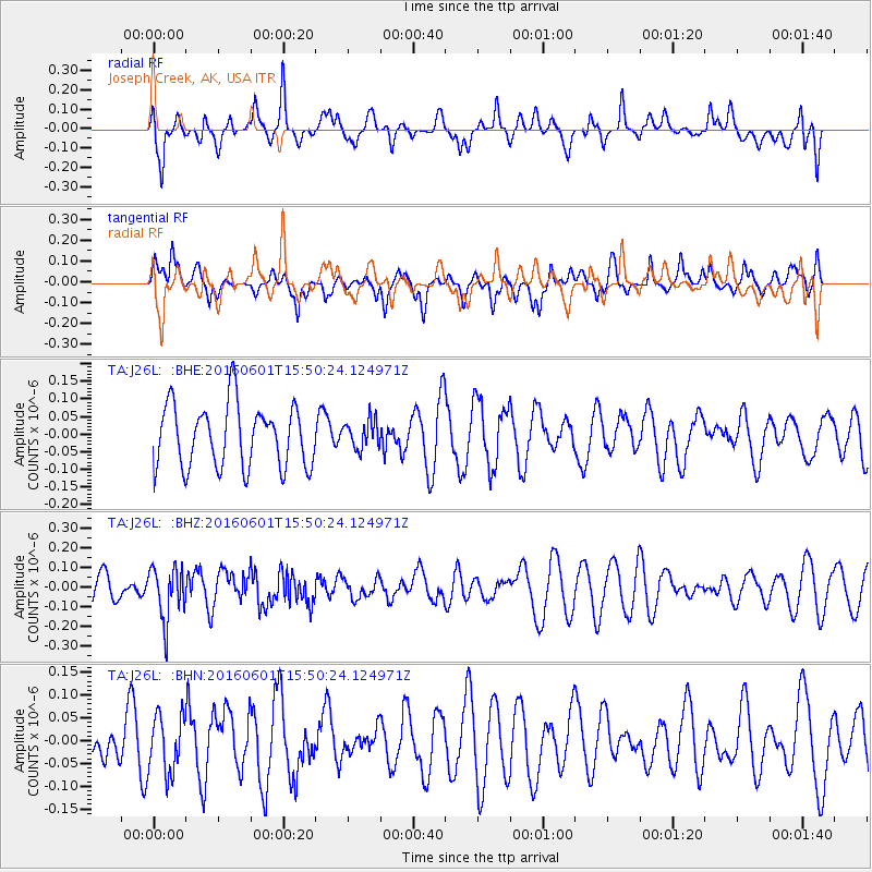
J26L Joseph Creek, AK, USA - Earthquake Result Viewer
*The percent match for this event was below the threshold and hence no stack was calculated.
| Earthquake location: |
Kermadec Islands, New Zealand |
| Earthquake latitude/longitude: |
-30.2/-178.0 |
| Earthquake time(UTC): |
2016/06/01 (153) 15:37:23 GMT |
| Earthquake Depth: |
44 km |
| Earthquake Magnitude: |
5.5 MWC, 5.5 MWC |
| Earthquake Catalog/Contributor: |
NEIC PDE/NEIC COMCAT |
|
| Network: |
TA USArray Transportable Network (new EarthScope stations) |
| Station: |
J26L Joseph Creek, AK, USA |
| Lat/Lon: |
64.50 N/143.56 W |
| Elevation: |
1144 m |
|
| Distance: |
98.2 deg |
| Az: |
14.3 deg |
| Baz: |
209.598 deg |
| Ray Param: |
$rayparam |
*The percent match for this event was below the threshold and hence was not used in the summary stack. |
|
| Radial Match: |
62.402626 % |
| Radial Bump: |
400 |
| Transverse Match: |
44.42661 % |
| Transverse Bump: |
362 |
| SOD ConfigId: |
7422571 |
| Insert Time: |
2019-04-22 17:30:25.737 +0000 |
| GWidth: |
2.5 |
| Max Bumps: |
400 |
| Tol: |
0.001 |
|
Signal To Noise
| Channel | StoN | STA | LTA |
| TA:J26L: :BHZ:20160601T15:50:24.124971Z | 2.0504246 | 1.3324468E-7 | 6.4983944E-8 |
| TA:J26L: :BHN:20160601T15:50:24.124971Z | 0.9957252 | 6.250827E-8 | 6.277663E-8 |
| TA:J26L: :BHE:20160601T15:50:24.124971Z | 0.45192614 | 4.0230578E-8 | 8.9020254E-8 |
| Arrivals |
| Ps | |
| PpPs | |
| PsPs/PpSs | |


