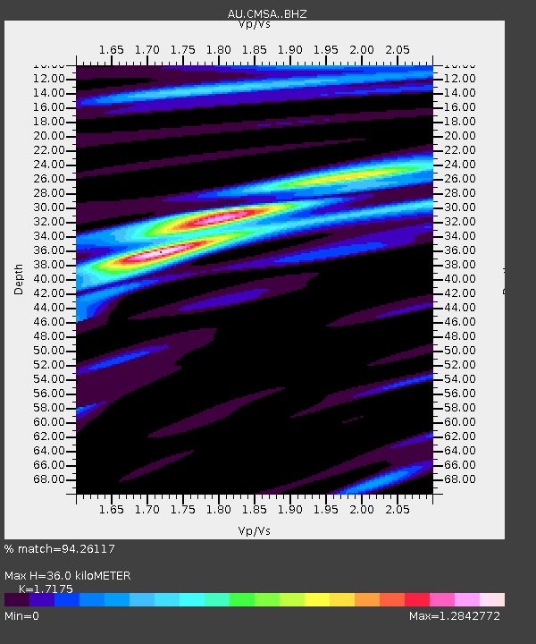
CMSA Cobar, New South Wales - Earthquake Result Viewer

Earthquake location: Southern Sumatra, Indonesia
Earthquake latitude/longitude: -2.1/100.7
Earthquake time(UTC): 2016/06/01 (153) 22:56:00 GMT
Earthquake Depth: 50 km
Earthquake Magnitude: 6.6 MWW, 6.4 MWB, 6.6 MWC, 6.7 MWC
Earthquake Catalog/Contributor: NEIC PDE/NEIC COMCAT
Network: AU Australian Seismological Centre
Station: CMSA Cobar, New South Wales
Lat/Lon: 31.54 S/145.69 E
Elevation: 220 m
Distance: 51.5 deg
Az: 129.522 deg
Baz: 295.469 deg
Ray Param: 0.06721907
Estimated Moho Depth: 36.0 km
Estimated Crust Vp/Vs: 1.72
Assumed Crust Vp: 6.522 km/s
Estimated Crust Vs: 3.797 km/s
Estimated Crust Poisson's Ratio: 0.24
Radial Match: 94.26117 %
Radial Bump: 317
Transverse Match: 86.98596 %
Transverse Bump: 400
SOD ConfigId: 7422571
Insert Time: 2019-04-22 17:34:06.834 +0000
GWidth: 2.5
Max Bumps: 400
Tol: 0.001

Signal To Noise

ChannelStoNSTALTA
AU:CMSA: :BHZ:20160601T23:04:31.09401Z18.6792326.2536365E-63.347909E-7
AU:CMSA: :BHN:20160601T23:04:31.09401Z9.3047121.47368E-61.5837998E-7
AU:CMSA: :BHE:20160601T23:04:31.09401Z6.71844862.6196954E-63.8992562E-7
Arrivals
Ps4.2 SECOND
PpPs14 SECOND
PsPs/PpSs18 SECOND