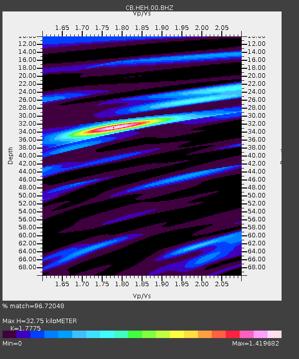
HEH Heihe,Heilongjiang Province - Earthquake Result Viewer
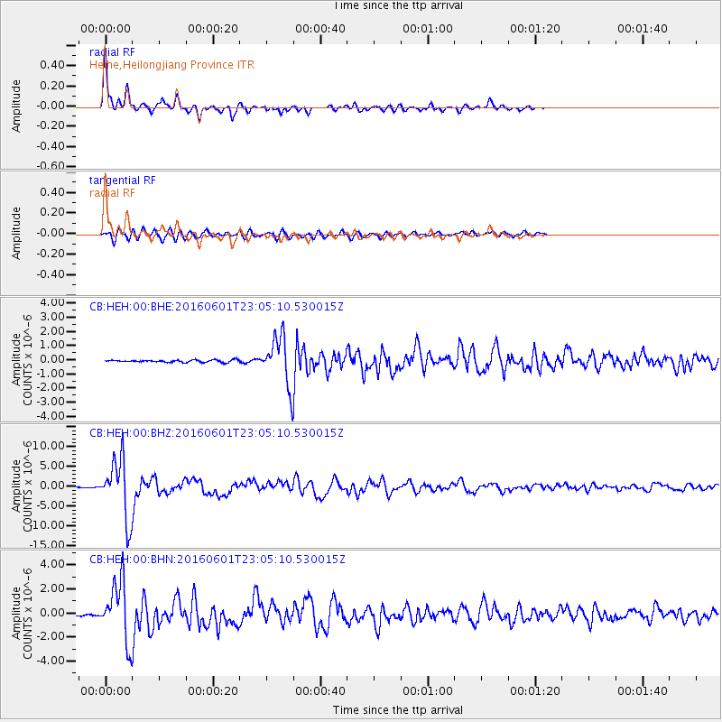
Earthquake location: Southern Sumatra, Indonesia
Earthquake latitude/longitude: -2.1/100.7
Earthquake time(UTC): 2016/06/01 (153) 22:56:00 GMT
Earthquake Depth: 50 km
Earthquake Magnitude: 6.6 MWW, 6.4 MWB, 6.6 MWC, 6.7 MWC
Earthquake Catalog/Contributor: NEIC PDE/NEIC COMCAT
Network: CB China National Seismic Network
Station: HEH Heihe,Heilongjiang Province
Lat/Lon: 50.25 N/127.41 E
Elevation: 165 m
Distance: 57.0 deg
Az: 20.155 deg
Baz: 212.438 deg
Ray Param: 0.06367536
Estimated Moho Depth: 32.75 km
Estimated Crust Vp/Vs: 1.78
Assumed Crust Vp: 6.419 km/s
Estimated Crust Vs: 3.611 km/s
Estimated Crust Poisson's Ratio: 0.27
Radial Match: 96.72048 %
Radial Bump: 299
Transverse Match: 83.94947 %
Transverse Bump: 400
SOD ConfigId: 7422571
Insert Time: 2019-04-22 17:34:52.633 +0000
GWidth: 2.5
Max Bumps: 400
Tol: 0.001

Signal To Noise

ChannelStoNSTALTA
CB:HEH:00:BHZ:20160601T23:05:10.530015Z89.5735557.426479E-68.290928E-8
CB:HEH:00:BHN:20160601T23:05:10.530015Z44.7152372.4682035E-65.5198267E-8
CB:HEH:00:BHE:20160601T23:05:10.530015Z21.0753021.6812629E-67.977408E-8
Arrivals
Ps4.2 SECOND
PpPs13 SECOND
PsPs/PpSs18 SECOND