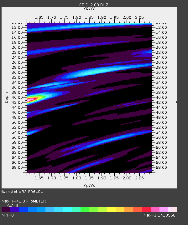
DL2 Dalian,Liaoning Province - Earthquake Result Viewer

Earthquake location: Southern Sumatra, Indonesia
Earthquake latitude/longitude: -2.1/100.7
Earthquake time(UTC): 2016/06/01 (153) 22:56:00 GMT
Earthquake Depth: 50 km
Earthquake Magnitude: 6.6 MWW, 6.4 MWB, 6.6 MWC, 6.7 MWC
Earthquake Catalog/Contributor: NEIC PDE/NEIC COMCAT
Network: CB China National Seismic Network
Station: DL2 Dalian,Liaoning Province
Lat/Lon: 38.91 N/121.63 E
Elevation: 65 m
Distance: 45.1 deg
Az: 23.192 deg
Baz: 210.291 deg
Ray Param: 0.07134004
Estimated Moho Depth: 41.0 km
Estimated Crust Vp/Vs: 1.60
Assumed Crust Vp: 6.134 km/s
Estimated Crust Vs: 3.834 km/s
Estimated Crust Poisson's Ratio: 0.18
Radial Match: 93.806404 %
Radial Bump: 267
Transverse Match: 83.155945 %
Transverse Bump: 326
SOD ConfigId: 7422571
Insert Time: 2019-04-22 17:34:53.941 +0000
GWidth: 2.5
Max Bumps: 400
Tol: 0.001

Signal To Noise

ChannelStoNSTALTA
CB:DL2:00:BHZ:20160601T23:03:41.90001Z53.771637.2992716E-61.3574578E-7
CB:DL2:00:BHN:20160601T23:03:41.90001Z41.7269483.824829E-69.166328E-8
CB:DL2:00:BHE:20160601T23:03:41.90001Z14.6523311.6024858E-61.0936729E-7
Arrivals
Ps4.3 SECOND
PpPs16 SECOND
PsPs/PpSs21 SECOND